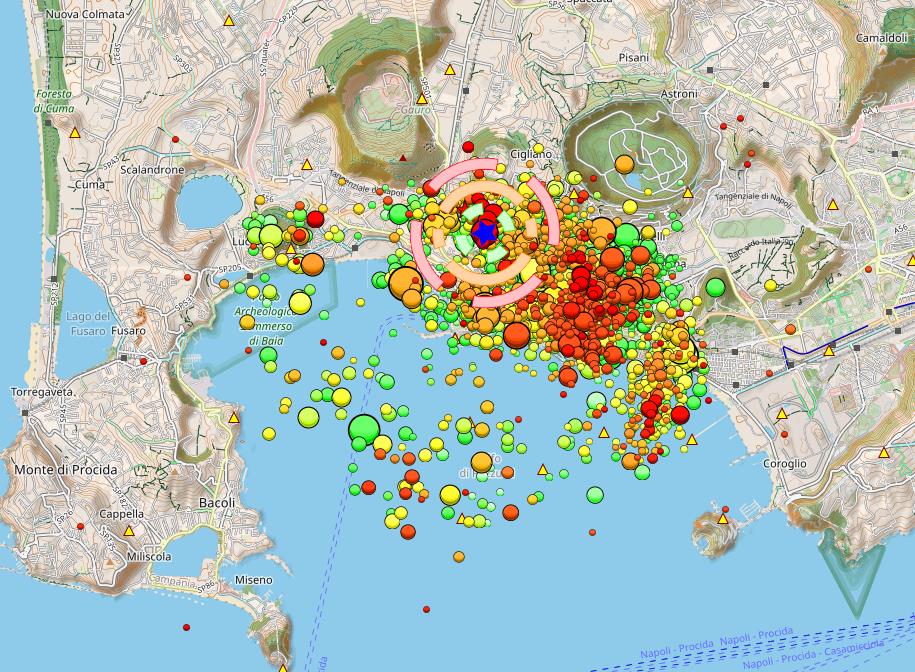
Renewed Seismic Swarm hits Campi Flegrei – Epicenter close to critical Tangenziale Highway
Last night, the Campi Flegrei caldera was once again shaken by a seismic swarm. The strongest event reached a magnitude of 3.2, with the hypocenter located about 2,700 meters deep—beneath the hydrothermal system. Two additional quakes, measuring M2.2 and M2.0, occurred just before and after the main shock. All three epicenters were located northeast of Solfatara, near the Tangenziale highway that connects Pozzuoli to Naples.
This highway is the region’s main evacuation route in the event of a volcanic eruption. It passes through tunnels beneath the caldera’s volcanic hills. A stronger earthquake—above magnitude 5—could seriously damage this critical infrastructure, significantly complicating any last-minute evacuation. Therefore, expanding evacuation capacity via the sea appears increasingly necessary.
The M3.2 tremor was widely felt in Pozzuoli and nearby areas. Many residents reported it on social media. One user expressed concern about potential damage to the ruins of Pompeii, where a similar quake last month caused a wall to collapse.
The latest swarm began at 23:00 UTC and included around 30 individual tremors. Recent hopes that seismic activity might be declining—based on a few quieter days—now seem premature. Past patterns suggest that calmer phases often precede more intense swarms. As long as ground uplift continues, seismic stress will keep building. Even temporary slowdowns in uplift, as seen in past years, are no indication that the unrest is ending.
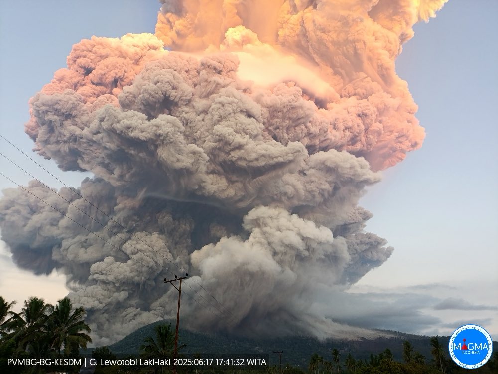
Lewotobi Laki-Laki: Powerful eruption sends ash 15 km high and triggers pyroclastic flows
On Tuesday at 17:35 local time (09:35 UTC), Indonesia’s Lewotobi Laki-Laki volcano on Flores Island erupted violently. The Darwin VAAC reported an ash plume reaching up to 15 kilometers into the atmosphere, spreading over a wide area and remaining detectable 150 kilometers away.
According to the Indonesian disaster agency, the ash column rose 10,000 meters above the crater, approximately 11,584 meters above sea level. The eruption is ongoing, and authorities have raised the alert level to the maximum (IV).
Photos show multiple pyroclastic flows racing down the volcano’s flanks. Experts from the VSI warned of potential lahars if heavy rains occur, though the region is currently in its dry season.
Ashfall has been reported in all directions, particularly in the east and southeast. Residents were advised to wear masks and avoid the area.
Preparations for evacuation are underway. No casualties have been reported, but many locals are leaving nearby villages voluntarily.
Access to the volcano has been widely restricted. A 7-kilometer exclusion zone is in place, extending to 8 kilometers in the southwest-northeast sector.
Indonesia’s aviation authority issued a red alert for air traffic. Significant flight disruptions occurred, especially on routes between Australia and Bali, with numerous cancellations.
This eruption is part of a recent eruptive phase. Similar explosive activity was recorded in March, April, and May, each preceded by brief seismic crises.
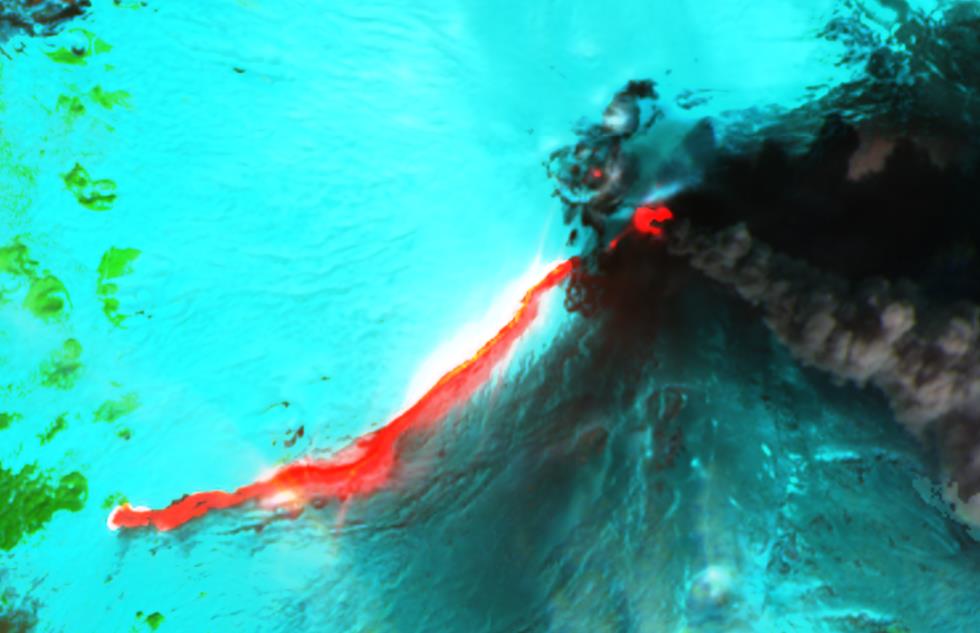
Thermal Anomaly at Ol Doinyo Lengai Suggests Lava Overflow
Tanzania’s Ol Doinyo Lengai, the world’s only active volcano erupting sodium-carbonatite lava, is showing signs of increased activity. A Sentinel satellite captured a significant thermal anomaly on May 27 that filled the entire summit crater—an unusual event for a volcano whose lava, at just 500–600°C, is too cool to glow visibly during the day.
Normally, small infrared hotspots hint at active hornitos—small lava vents—but the scale of this anomaly suggests a lava overflow, possibly triggered by the collapse of a hornito and the release of a lava pond across the crater floor.
Increased thermal signals have persisted in subsequent satellite imagery. These observations align with earlier geophysical data collected by an international team led by Sarah Stamps and Ntambila Daud of Virginia Tech. Since 2016, six GNSS stations installed around the volcano have monitored subtle ground deformation. Between March and December 2022, researchers detected rapid uplift, followed by steady elevation through August 2023. No deformation was recorded before or after, and modeling suggests the activity was caused by a shallow magmatic intrusion—potentially marking a phase of volcanic heating.
Despite these signs, on-site observations remain rare. Post-pandemic cost hikes have sharply reduced expeditions to the remote Rift Valley region. Even fewer eyewitness reports come from Nyamuragira volcano in the Democratic Republic of Congo, where insecurity and conflict near Goma further hinder access. Nyamuragira remains far more active than Lengai, emitting thermal energy levels over 1,980 megawatts—compared to just single-digit values at Ol Doinyo Lengai.
Damage after earthquake in Colombia on June 8, 2025
A strong earthquake with a magnitude of 6.3 struck Colombia at 13:08 UTC (08:08 local time). According to the EMSC, the epicenter was located 23 km east of Medina, around 100 km east of the capital Bogotá. The hypocenter was only 9 km deep, which amplified the effects on the surface. Moderate damage was reported, including several buildings that collapsed near the epicenter. Social media images show destroyed houses, fallen façade parts, and cracks in roads and buildings. There have been no reports of fatalities so far, but panic reactions among the population have been reported.
The quake can be explained by Colombia’s complex tectonic setting. The Nazca and Caribbean Plates converge with the so-called North Andes Block. The earthquake occurred along the East Andean Fault Zone, a major fault in Colombia’s interior. Several aftershocks followed the main event.
Colombia is also volcanically active, with 14 volcanoes classified as potentially active, including Galeras, Nevado del Huila, and Nevado del Ruiz. The latter is located about 250 km from the epicenter and is currently erupting. Today, the VAAC reported ash clouds at 6,100 meters altitude. There is a possibility that the earthquake could influence the volcano and trigger a stronger eruption in the near future.
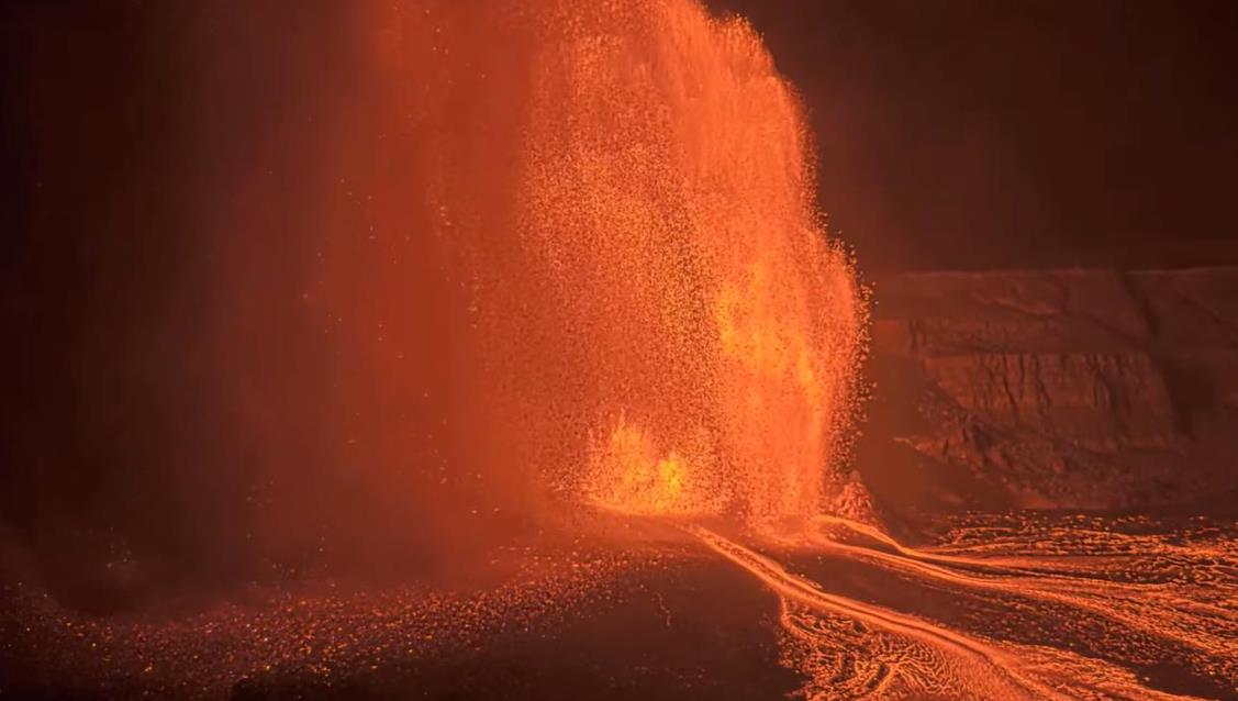
The 24th eruption episode has begun at Kilauea – lava fountain 300 m high
Hilo, June 5, 2025
Hawaiʻi’s Kīlauea volcano has erupted again: the 24th eruption of the current phase, ongoing since December 23, 2024, began overnight. A lava fountain over 300 meters high shot lava up to the rim of Halemaʻumaʻu crater, while large lava flows now cover its entire floor.
The eruption started on June 4 at around 9:15 PM HST (07:15 UTC, June 5), with initial fountains reaching about 30 meters. By 10:27 PM HST, activity had intensified significantly, with fountains reaching 150 meters — and shortly after, exceeding 300 meters. The main activity is from the northern vent, while the southern vent is producing a smaller, 50-meter-high fountain.
Warning signs appeared in the afternoon, with intermittent lava spattering. A lava flow began shortly before the fountain activity — a typical paroxysmal pattern, also seen recently at Etna and Fuego.
Significant ground inflation of about 12 µRad was recorded after the previous eruption on May 26 — one of the highest values since episodic activity resumed, indicating a strong paroxysm with potential for further escalation.
Authorities are closely monitoring the situation. While there is currently no direct threat to the public, visitors to Hawaiʻi Volcanoes National Park are strongly urged to stay within designated safety zones.
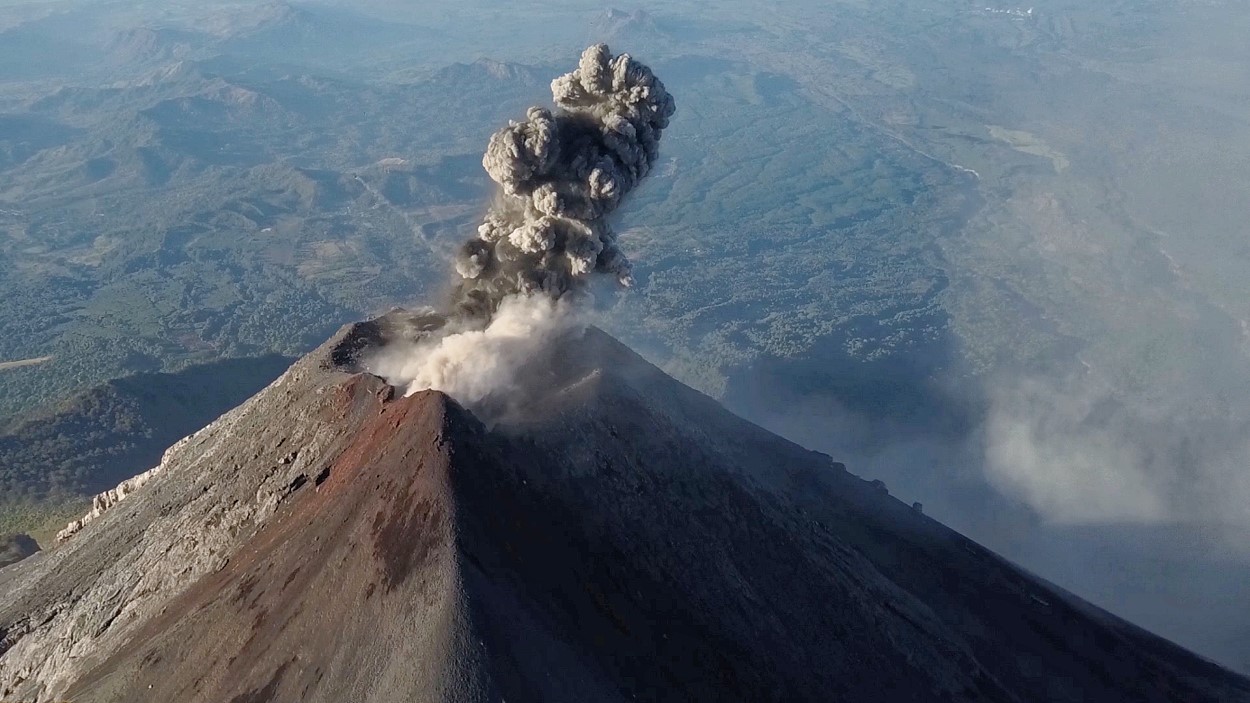
Guatemala’s Fuego volcano experienced a paroxysmal eruption overnight, producing lava fountains up to 300 m high, lava flows, and several pyroclastic flows that reportedly reached near the base of the volcano.
The national volcano institute INSIVUMEH issued a warning in a Spanish-language bulletin, shared only as an image on social media — making translation difficult and limiting access to critical information, especially for foreign tourists. This reflects a broader global issue in emergency communication.
Later, the civil protection agency CONRED released a translatable bulletin confirming pyroclastic density currents in the Seca, Ceniza, and Las Lajas ravines. These were classified as weak to moderate but could intensify. Ashfall affected several towns west and northwest of the volcano, particularly Acatenango and San Pedro Yepocapa.
The situation remains critical in southern areas. Emergency teams are patrolling and monitoring local communities. Road RN 14 was closed due to the threat of pyroclastic flows crossing it.
CONRED urged the tourism authority INGUAT and local governments to restrict access to nearby Acatenango volcano. 500 residents were evacuated. Both residents and tourists were advised to stay informed and keep a 72-hour emergency bag ready in case evacuation becomes necessary.
Pyroclastic Flow on the Eastern Flank of Etna – many people close to the eruption
Catania, June 2, 2025 – 11:45 AM
During Etna’s 14th eruptive phase — considered a mild paroxysm — a pyroclastic flow unexpectedly occurred at 11:24 AM CEST. It originated from the northeastern flank of the Southeast Crater and surged through the Valle del Bove, partially reaching the Valle del Leone.
The flow was likely triggered by the collapse of a lava flow or a section of the crater flank due to the ongoing activity. Pyroclastic flows on Etna often result from lava breaking through the cone’s sides, causing structural collapse.
Preliminary assessments suggest this was one of the largest pyroclastic flows ever observed at Etna. The INGV later stated the flow likely did not extend beyond the Valle del Leone’s boundary — crucial, as this ridge (Serra delle Concazze) is frequented by hikers.
Simultaneously, strombolian activity intensified into a lava fountain. It remains unclear whether a sudden pressure build-up caused the collapse or whether the collapse itself triggered explosive decompression of magma. Volcanic ash was detected at 6,400 m altitude, prompting a red alert from VAAC Toulouse.
Recent monitoring indicated magma accumulation beneath the Southeast Crater in a north-south trending zone. Previous eruptions had already revealed new vents on the northwest side, suggesting structural weakness.
This incident highlights the unpredictability and danger of volcanoes — and raises concerns about tourist safety. While access to Stromboli is strictly limited even during normal activity, visitors are transported by cable car and bus to within 300 m of Etna’s active craters — despite significantly higher eruption levels. A glaring safety gap that demands attention.
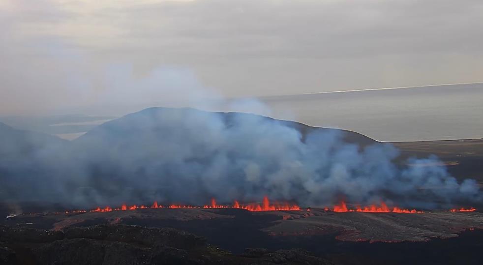
Eruption and dyke formation at Sundhnúkur – Lava Flows Toward Grindavík
This morning at 9:47 a.m. local time (11:47 a.m. CEST), the anticipated volcanic eruption began on the Reykjanes Peninsula in Iceland. Once again, a fissure opened in the Sundhnúkur crater system—this time significantly farther south than in previous eruptions. The new fissure cuts through the protective barrier built north of Grindavík, and lava is now flowing toward the town.
Unlike the eruptions in the latter half of 2024, today’s event was preceded by a powerful earthquake swarm. Interestingly, the Icelandic Meteorological Office (IMO) had yet to update its shakemaps early this morning, suggesting the new data was not incorporated until office hours began. However, Icelandic media outlet MBL reported early signs of a magma intrusion underground. Initial earthquake data did not reflect unusual activity, leading some to briefly suspect an April Fool’s hoax—proof that even a date can be deceiving.
But the eruption is very real. Live camera footage shows that a new fissure has opened south of the volcanic ridge of Hagafell. The fissure is estimated to be about 500 meters long, though the lava fountains are currently less intense than in previous eruptions. Given that the eruption began just over an hour ago, the event may still be in its early stages and could intensify. Further fissures are also a possibility.
Grindavík was evacuated immediately as the seismic crisis began this morning, though eight residents reportedly refused to leave. As of this writing, the fissure has extended dangerously close to a greenhouse near the town. However, the main fissure appears to be expanding northward—away from Grindavík. The nearby Svartsengi geothermal plant is currently not under direct threat. Lava is primarily spreading toward Mount Þorbjörn.
According to the IMO, the magmatic dike driving this eruption is over 11 kilometers long, making it the largest intrusion of its kind since November 2023. Scientists believe that this may be more than just a release of previously accumulated magma. The intensity of seismic activity suggests that fresh magma from greater depths may also be rising to the surface.
As the situation evolves, authorities are monitoring the eruption closely, ready to respond to any changes in the lava flow direction or eruption intensity.
Subterminal Eruption at Mount Etna: Lava Flow on the Southern Flank
After several months of inactivity, Mount Etna in Sicily has erupted again, producing a lava flow descending its southern flank. Notably, this is a rare subterminal eruption: instead of originating from the central crater, the lava flow emerges from a short fissure at the base of the central crater complex.
According to INGV volcanologist Boris Behnke, the eruption likely began in the afternoon but only became visible after nightfall. Since Thursday, volcanic tremor has been increasing, indicating rising magma. Additionally, weak Strombolian eruptions and ash emissions were observed.
Seismic activity beneath Etna had already intensified last month, suggesting magma ascent. Whether this magma has reached the surface remains uncertain. More likely, the rising magma increased pressure in a shallow reservoir, forcing stored molten rock to escape. The gas pressure is insufficient for an explosive eruption from the main craters, but if larger volumes of fresh magma reach higher levels of the conduit system, paroxysmal eruptions could occur.
Volcán de Fuego in Guatemala is a stratovolcano (also called a composite volcano). It is one of Central America’s most active volcanoes, known for its frequent eruptions that produce strombolian and vulcanian activity, including explosions, lava flows, and pyroclastic flows.
Fuego is part of the Guatemalan volcanic arc, which is formed by the subduction of the Cocos Plate beneath the Caribbean Plate. It is located near Antigua, Guatemala, and is famous for its persistent activity, often visible from the surrounding areas.
Volcán de Fuego in Guatemala is famous for:
Frequent Eruptions – It is one of the most active volcanoes in Central America, with near-continuous activity, including strombolian eruptions, lava flows, and ash clouds.
Striking Appearance – Fuego is a classic stratovolcano, often seen with its near-constant plumes of ash and gas, making it a dramatic sight, especially from the nearby tourist city of Antigua, Guatemala.
Climbing & Adventure Tourism – Many hikers climb Acatenango, its neighboring volcano, for an incredible view of Fuego’s eruptions at night, where glowing lava and explosions light up the sky.
Cultural and Historical Significance – The volcano has been recorded in Mayan history and is part of Guatemala’s rich volcanic landscape. It has influenced local communities for centuries.
Deadly 2018 Eruption – On June 3, 2018, Fuego had one of its most catastrophic eruptions, producing pyroclastic flows that buried villages like San Miguel Los Lotes, killing hundreds of people. It was one of Guatemala’s deadliest volcanic disasters.
The 2018 Eruption of Volcán de Fuego
On June 3, 2018, Volcán de Fuego in Guatemala experienced one of its most catastrophic eruptions in recorded history. The eruption resulted in widespread devastation, significant loss of life, and lasting impacts on the affected communities.
Overview of the Eruption
Volcán de Fuego, one of Central America’s most active volcanoes, had been showing increased activity in the days leading up to the disaster. However, the intensity of the eruption on June 3 far exceeded expectations. The eruption was classified as a Plinian event, characterized by a massive ash column and violent pyroclastic flows.
Sequence of Events
Morning Activity: Early in the day, Fuego exhibited increased ash emissions, explosions, and lava flows. Authorities monitored the situation but did not initially expect a large-scale disaster.
Main Eruption: At approximately 3:00 PM, the volcano erupted explosively, sending an ash column over 10 kilometers (33,000 feet) into the atmosphere.
Pyroclastic Flows: The most destructive aspect of the eruption was the pyroclastic flows — a deadly mix of superheated gas, ash, and volcanic material traveling at speeds exceeding 100 km/h (62 mph). These flows engulfed multiple villages, including San Miguel Los Lotes and El Rodeo, causing extreme destruction.
Casualties and Impact: The eruption led to the deaths of at least 200 people, with hundreds still missing. Thousands were displaced, and entire communities were buried under thick layers of ash and debris.
Ashfall and Disruptions: Heavy ashfall extended to Guatemala City, leading to airport closures and transportation disruptions.
Why Was It So Deadly?
The sudden escalation of the eruption, combined with limited evacuation time, contributed to the high number of casualties. Unlike Fuego’s usual eruptions, which are frequent but moderate, this event produced rapid and powerful pyroclastic flows, giving residents little chance to escape.
Aftermath and Recovery
In the weeks following the disaster, emergency teams, including firefighters, military personnel, and volunteers, worked to rescue survivors and recover bodies. However, the solidified volcanic material made search efforts difficult.
Over 12,000 people were evacuated, and many survivors were permanently displaced.
San Miguel Los Lotes was declared uninhabitable, and survivors were relocated to temporary shelters.
International aid and government assistance were deployed, but recovery efforts faced challenges due to the scale of destruction.
Legacy of the Eruption
The 2018 eruption of Volcán de Fuego remains a stark reminder of the unpredictable power of nature. Today, the volcano continues to be closely monitored, and new evacuation protocols have been implemented to prevent future tragedies. The scars of the eruption are still visible in the affected areas, serving as a somber testament to the disaster.
This event underscores the importance of volcanic monitoring, early warning systems, and preparedness to mitigate the impact of future eruptions in Guatemala and around the world.
 Last night, the Campi Flegrei caldera was once again shaken by a seismic swarm. The strongest event reached a magnitude of 3.2, with the hypocenter located about 2,700 meters deep—beneath the hydrothermal system. Two additional quakes, measuring M2.2 and M2.0, occurred just before and after the main shock. All three epicenters were located northeast of Solfatara, near the Tangenziale highway that connects Pozzuoli to Naples.