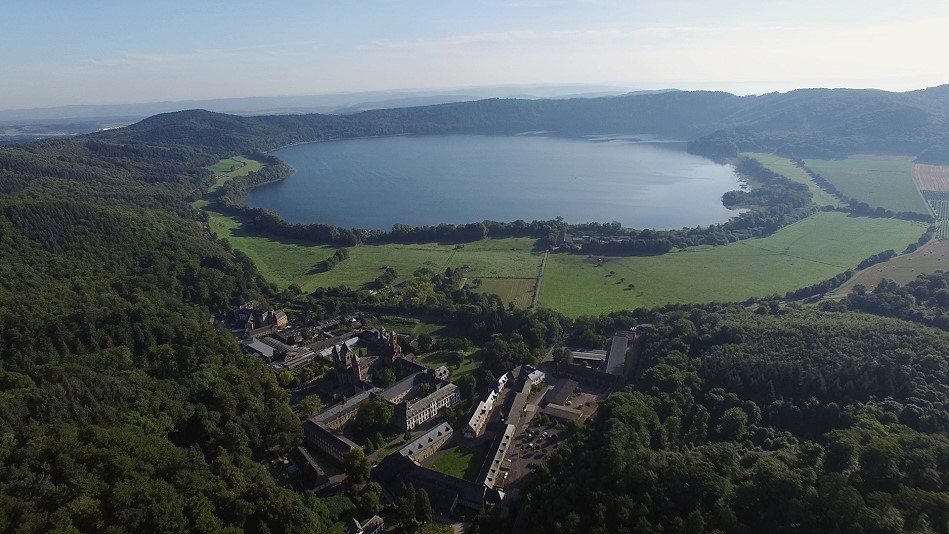
Phreatic Eruptions at Gunung Suoh Volcano

Three unexpected phreatic eruptions occurred in the Nirvana crater of Suoh volcano on Sumatra, Indonesia, yesterday morning at 8:30 a.m. WIB. The PVMGB of the Indonesian Volcanological Observatory reported that the eruptions produced dense, pure white steam clouds that rose up to 500 meters high and spread widely.

VSI volcanologists advised residents to maintain a minimum distance of 500 meters from the crater and avoid lowlands and river valleys due to the potential spread of volcanic gases, particularly carbon dioxide. This gas is heavier than air and can accumulate in low-lying areas, posing a risk of suffocation.

Gunung Suoh, also known as Mount Suwoh and Pematang Bata, is located in the Barisan Selatan National Park in the Lampung Special Administrative Region of southern Sumatra. Although Suoh is relatively unknown, it lies just 150 kilometers from the more famous island volcano, Anak Krakatau.

Another earthquake swarm rattles Campi Flegrei

After several relatively calm days, an intense earthquake swarm resumed yesterday evening beneath the southern Italian Caldera Campi Flegrei. Within 24 hours, around 160 earthquakes were recorded, more than in most weeks. The strongest tremor had a magnitude of 3.2 and was located 1.6 kilometers deep. Although the epicenter was within the hydrothermal system area, the strength of the earthquake suggests it was related to rock fracturing. Despite occurring during the volcano’s dormant period, there were reports of perceptions, even from the Sorrento area. The Shakemap shows increased weak earthquakes over a large radius, indicating accelerated ground uplift.

Four additional earthquakes had magnitudes in the range of two, with the strongest being 2.9. Interestingly, the stronger earthquakes clustered in the outer eastern flank of the Solfatara crater, near the Pisciarelli fumaroles, the area with the strongest geothermal manifestations of the Solfatara. As a result of the strong ground uplift in April, the gas temperature of the main fumarole briefly rose to 96 degrees but decreased to 94 degrees last week. Newspaper reports suggest that a magma body is accumulating at a depth of about 4 kilometers, which could lead to a volcanic eruption quickly in the event of a crack in the caldera’s cover rock.

Ruang: Strong eruption in Indonesia

Strong explosions shook the Indonesian volcano Ruang, resulting in pyroclastic flows and volcanic thunderstorms. An ash cloud reached a height of 19 kilometers and spread southwestward, even reaching Sulawesi, where the International Airport of Manado had to be closed. Strong volcanic thunderstorms accompanied the eruption clouds, accompanied by thousands of lightning strikes. Pyroclastic flows flowed down the volcano in all directions, reaching the sea. Footage showed burning houses on the island, which had already been evacuated. It is unclear if there were any casualties.

The warning time was short, with a rapid increase in volcano-tectonic earthquakes the day before the eruption. The earthquakes began at depth and shifted towards the surface with ascending magma. A exclusion zone with a radius of 7 kilometers was established around the crater. The main explosions generated seismic signals with a maximum amplitude of 55 mm and durations of 360 and 600 seconds. The alert status is “Red”.

Ruang: Powerful eruptions generating lightnings

Explosions of considerable force rocked Ruang, generating volcanic thunderstorms and propelling volcanic ash nearly 14 kilometers into the sky. Within a short span, a formidable eruption occurred at the Indonesian island volcano Ruang, ejecting volcanic ash to an altitude of nearly 14 kilometers. Footage captured the expulsion of red-hot tephra and volcanic ash from the crater, accompanied by flashes of lightning within the eruption cloud—a hallmark of volcanic thunderstorms. Prompt evacuations were initiated for two settlements situated at the volcano’s base.

The swift evolution of the eruption is striking: on April 13, a series of volcano-tectonic earthquakes were documented. By the following day, seismic activity intensified significantly, with over 150 earthquakes recorded. Within the subsequent 24 hours, seismicity surged further, with 374 volcanic earthquakes registered. Consequently, the alert level on the volcano advisory system swiftly escalated from “green” to “yellow,” then “orange,” and ultimately to “red” by the previous day.

Iceland: Fourth eruption within 4 months

On Saturday evening, another volcanic eruption began in Iceland. It is the 4th eruption to occur at Svartsengi on Reykjanes within 4 months. Around 8:30 p.m. local time, a 3-kilometer-long fissure opened east of Svartsengi. Lava fountains fed a lava flow spreading in multiple directions. Towards the south, it flowed at a speed of 1 km/h towards the coast. Just before reaching the coastal road, the flow speed significantly slowed down. In the west, the lava flow disrupted the road to Grindavik and stopped 200 m before important pipelines.

By Sunday, the lava discharge rate had reduced, yet eruptions were still observed at 3 sections of the fissure. The volcanic eruption stabilized at a moderate level, with no end in sight.

It was the strongest eruption so far in the Svartsengi system. Within 21 hours, 30 million cubic meters of lava were ejected. They cover an area of approximately 8 square kilometers.

Another eruption started today in Iceland

The anticipated volcanic activity on Iceland’s Reykjanes Peninsula commenced shortly after 6 a.m. UTC today. Following a brief seismic disturbance lasting about 30 minutes, centered around Sýlingarfell, a 3-kilometer-long fissure opened at the eruption site first identified on December 18, 2023. This fissure extends approximately north to south, stretching from Sundhnúk in the south to the eastern tip of Stóra-Scógfel. Lava is flowing laterally from the fissure, primarily in an east-west direction. While there are lava fountains erupting along the fissure, the production rate seems slower compared to the December 18 event, potentially indicating a prolonged eruption this time.

Ground uplift showed a slight increase again yesterday evening, following minimal activity in the preceding 36 hours. It’s speculated that the rock above the magma chamber might have reached its elastic limit, causing increased back pressure in the conduit system, hindering the magma’s ascent. Confirmation of this hypothesis awaits further measurements to determine any subsequent ground subsidence.

Eruption on Iceland close to Grindavik

The expected volcanic eruption began this morning on Iceland’s Reykjanes Peninsula. A 900 m long eruption fissure opened 2 km north of Grindavik. Lava fountains along the fissure fed a lava flow that flowed in a southwesterly direction. In the afternoon a 1 m long fissure appeared on the outskirts of Grindavik. It is about 200 m from the nearest building. In the late afternoon a lava flow reached the first two houses. They burned down. At night the lava output decreased again. The eruption was preceded by a swarm earthquake lasting several hours. Significant ground uplift has been noted since the last eruption in December.

Iceland: Eruption started suddenly

The long-awaited eruption began on Iceland’s Reykjanes Peninsula yesterday evening. At 10:17 p.m. an approximately 4 km long eruption fissure opens between Stóra-Skógfell and the old Sundhnúkar crater series. Lava fountains shoot up to 100 m high. The delivery rate is estimated at 100 – 200 cubic meters per second. The flow speed is just under 1 km per hour. The distance from the southern end to the outskirts of Grindavík is almost 3 km.

The volcanic eruption was preceded by a seismic crisis that began 90 minutes before the eruption. The IMO tables show 538 shocks, the period again being 48 hours. A good 300 earthquakes occurred immediately before the eruption. If you look at the size of the fissure, there were very few earthquakes and the warning time was short. It can be assumed that the melt was less than 1 km below the surface. It had already risen to this depth shortly after the dyke intrusion on November 10th. Apparently later, the volcanologists’ assessments were incorrect that most of the melt in the dyke had solidified after just 2-3 weeks. There were probably no measurable magma movements because the pressure in the dyke was too great.

Stromboli with stronger eruption

Yesterday, there was an eruption at the Sicilian island volcano Stromboli that was larger than normal. Footage shared on social media depicts an ash cloud drifting southward above the volcano. A stronger explosion signal is evident in the seismic activity. However, the explosion wasn’t strong enough to prompt the INGV to issue an extraordinary bulletin. Yesterday, the LGS confirmed that the emission of carbon dioxide was high, with over 1100 tons of this odorless gas being emitted. Most other geophysical measurement values remained at a moderate activity level, except for the sound pressure generated during the typical Strombolian eruptions, which was classified as low, measuring 0.26 bar. The volcanic activity was characterized by Strombolian explosions and degassing activities in the northeastern and southwestern sectors of the crater. The increased carbon dioxide emission suggests an increased ascent of magma from depth. A similar signal is coming from deep earthquakes in the asthenosphere region, which have been increasingly recorded in recent days. In a few months, we could therefore experience another phase of lava activity at Stromboli.

Earthquake caused by magma intrusion near Grindavik on Iceland

There has been a strong swarm earthquake under Iceland’s Reykjanes Peninsula since October 25th. Several tremors had magnitudes in the region of five. The earthquakes were triggered by an accumulation of magma at a depth of 4-5 km and the ground rose. At the center of this uplift was the area around the Thorbjörn volcano near Svartsengi. On Friday November 10th, activity increased significantly and a dyke formed. It is 15 km long and runs from Kálffellsheiði on the northwest edge of Fagradalsfjall to under the sea near Grindavik. The place was evacuated because a major volcanic eruption is expected in the next few days.

Access to the area was cordoned off over a large area and a no-fly zone for drones was set up.