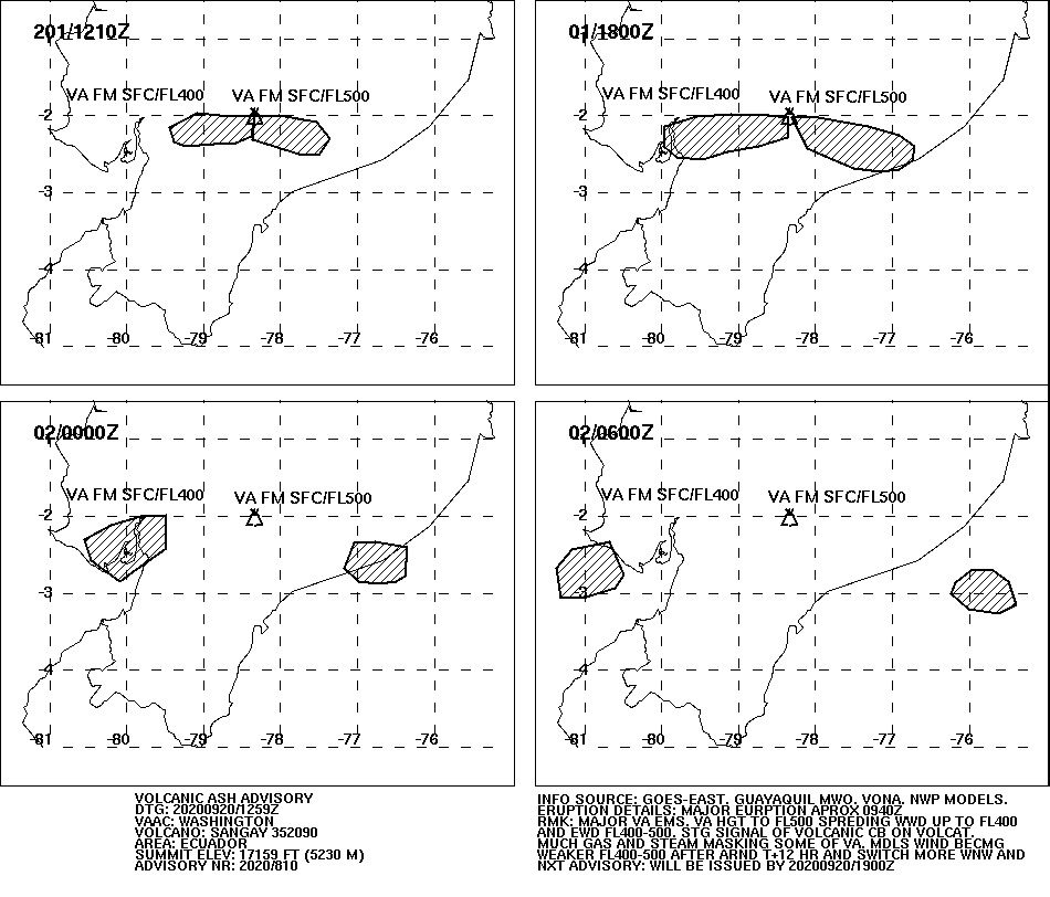
 Yesterday the sangay erupted very strongly. The eruption was explosive in nature and transported volcanic ash to an altitude of 50,000 feet, which is 15,240 meters above sea level. The VAAC reported the ash cloud at 12:59 UCT. In Ecuador it was 7:59 a.m. More explosions followed during the day, in which the explosions lost some of their force but still carried ash at more than 10,000 meters above sea level. At different altitudes, the air currents blew in different directions: The lower part of the eruption cloud was transported westward, the upper part eastward. This circumstance caused ash rain in 6 of the 24 provinces of the country. The regional airport of Guayaquil temporarily stopped its operations because the ash endangered air traffic. The country’s government promised to help the cattle ranchers to remove the ashes. It covers the pastures and contaminates the drinking water, not only for the cattle.
 Marc Szeglat
Los Angeles: Earthquake Mw 4,5
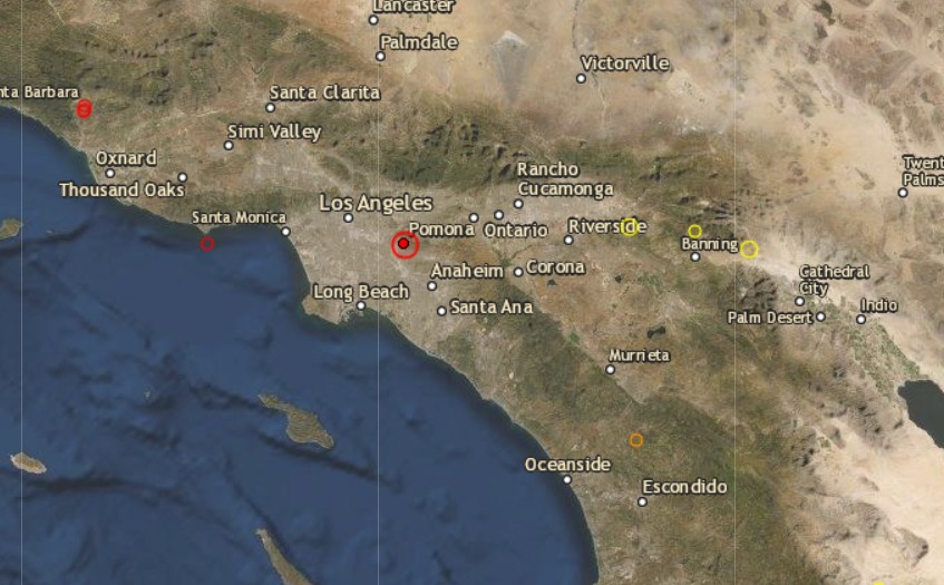 Yesterday morning, an earth tremor with a magnitude of 4.5 shook the greater Los Angeles area. The epicenter was 8 km east of Los Angeles. The depth of the epicenter was indicated by USGS as 18 km. According to the EMSC, the hypocenter was located at a depth of 20 km. In spite of the comparatively large depth of the focus, the earthquake was clearly perceived in the Los Angeles area. There are reports of small damages like cracks in house walls. Larger damages did not occur.
The earthquake manifested itself in the same fault zone as the 1987 Whittier Narrows earthquake, which had a magnitude of 5.9 and caused destruction in the city. The activated fault zone is the Puente Hills thrust fault, which is associated with the San Andreas Rift.
Translated with www.DeepL.com/Translator (free version)
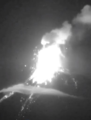
Sangay with further volcanic eruptions
 The Ecuadorian volcano Sangay keeps the local press busy, as it continues to be active and once ventured out of its cloud cover. On pictures you can see that on the southern flank of the volcano a deep channel has been created, through which lava flows and pyroclastic flows flow. In addition, the sangay is explosively active and promotes volcanic ash. The VAAC registered it today at an altitude of 6000 m. The ash drifts in a westerly direction. Media reports say that ash clouds have risen up to 870 m above crater height. Lahars now pose a permanent threat and influence the hydrology of the river landscape at the foot of the mighty volcano. Sangay is located at the edge of the Amazon basin, in one of the wettest regions on earth.
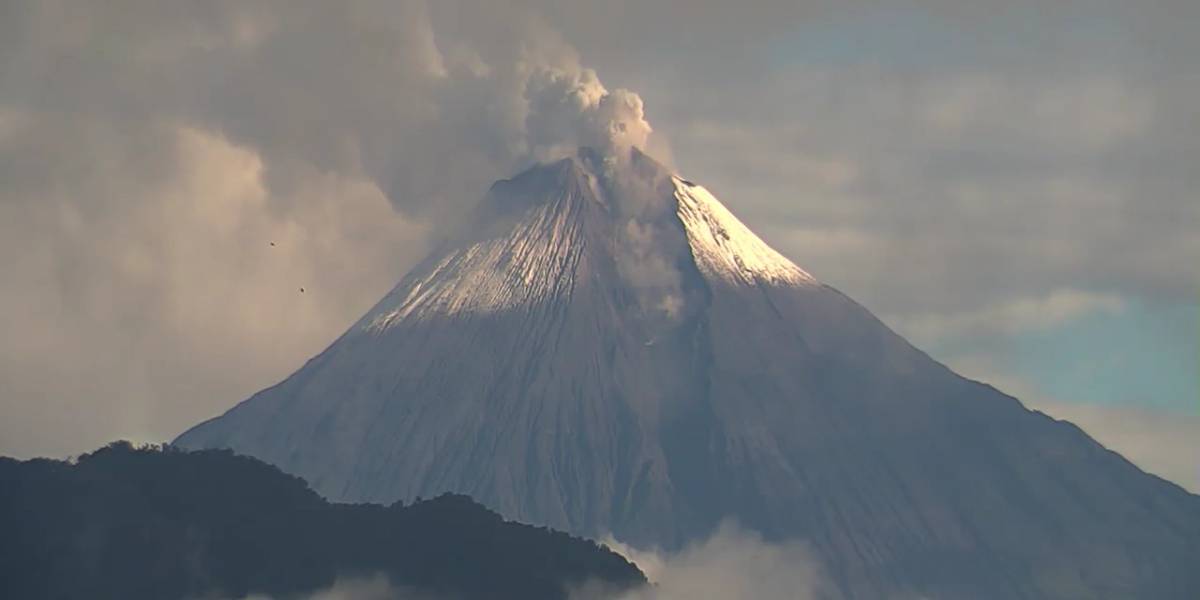
Pacaya erupts lava flows on 17.09.20
 The Guatemalan volcano Pacaya is still active today and erupts at least one lava flow, which flows over the southern flank of the volcano and has a length of 400 m. MIROVA registers a high thermal radiation with 234 MW power, which confirms the lava flow. The photo should show this lava flow. The exact date of the photo is not known. On the screenshot you can see not only the lava flowing out of a tunnel in the lower part of the McKenney cone, but also the volcanoes Agua and Fuego in the background. Speaking of McKenney crater. This one erupts strombolian. According to reports from INSIVUMEH, the ejection height of glowing tephra is up to 100 m.
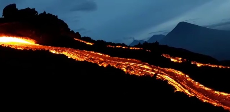
Fuego with double strike
 The Fuego in Guatemela never gets tired of spewing lava. Yesterday a rare double impact was recorded when 2 strombolian eruptions occurred directly after each other. Glowing tephra was ejected several hundred meters high. The lumps landed on the volcano flank and went down as debris avalanches.
INSIVUMEH reports 8-11 explosive eruptions per hour. The tephra rises up to 300 m above crater level. Volcanic ash makes it to 4700 m above sea level. The volcano continues to be effusive and erupts a lava flow. It flows through the erosion gully of Ceniza and is a good 100 m long. The warning of lahars remains because of the heavy rainfall. For the same reason our LiveCam has failed again. Despite water-protected technology it always finds a way to paralyze the cam. Ulli is trying to get the camera back online as soon as possible.
Grimsvötn: Earthquake M 3.3
 Tonight there was an earth tremor of magnitude 3.3 near Grimsvötn volcano. The epicenter was 11.1 km east of Hamarinn. The center of the earthquake was with 3.8 km relatively flat. Hamarinn is a subglacial volcano located in the west of the Icelandic glacier Vatnajökull and belongs to a system of crevasses that connects Grimsvötn and Bardarbunga. There have been 3 other weak earthquakes along the volcanic system.
Since a few weeks an increase of seismic activity at Grimsvötn can be observed. Volcanic experts assume that the volcano is preparing for an eruption. Whether and when a volcanic eruption will occur cannot be predicted yet.
Fuego increases activity in September
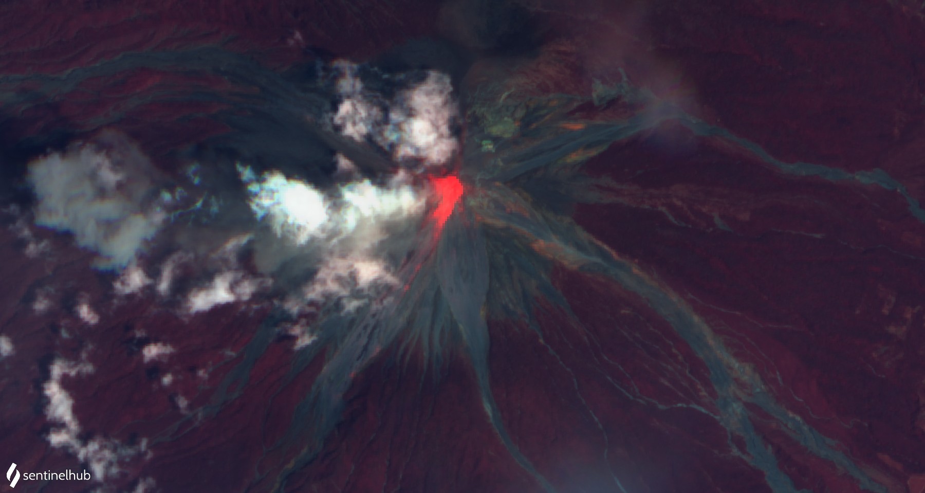 The Fuego in Guatemala has further increased its effusive and explosive activity. INSIVUMEH reports an increase in activity that began on September 5. However, there are significant variations in the intensity of activity. For example, a lava flow flows in the channel of Cenzia, whose length fluctuates between 100 and 650 m. On a recent sentinel satellite photo in the infrared range, the lava flow can be clearly seen. Hot avalanches are ejected from the lava front. Additionally, explosive eruptions occur. The VAAC Darwin issued 2 Vona warnings today, after which volcanic ash was detected at an altitude of 4600 m. Glowing tephra is ejected several hundred meters high and triggers debris avalanches on the flank. On the seismograms one can see numerous vibrations. Sometimes the explosions generate seismic signals with large peak amplitudes. Unfortunately, it is precisely during this phase of increased activity that our LiveCam failed. Our man on site is trying to get it back online quickly.
Chile: Earthquake Mw 6,3
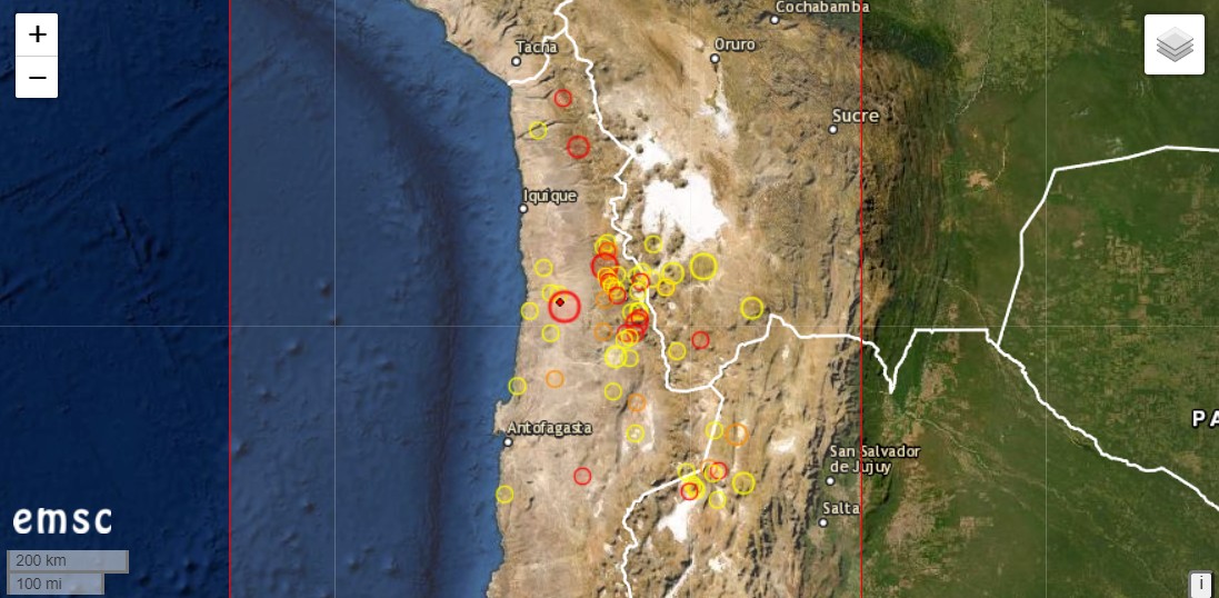
Another strong earthquake occurred in the Chilean region of Atacama. It had the magnitude 6.3 and was located 88 km north-north-east of Tocopilla. The depth of the earthquake is 45 km according to the EMSC. The earthquake occurred at 07:36 UCT. In Chile it was 04:36 UCT and the people were rudely torn from their sleep.
In the same area there had been an earthquake of magnitude 6.8 on September 1. One can assume that the two earthquakes are related. There were further aftershocks.
Several potentially active volcanoes are located in the Atacama. The Lascar is one of them. It showed signs of awakening at the beginning of the year and emitted heat radiation. The geyser field near the Tatio volcano is worth seeing.
Yellowstone Caldera: Yellowstone Caldera: Seismic swarm
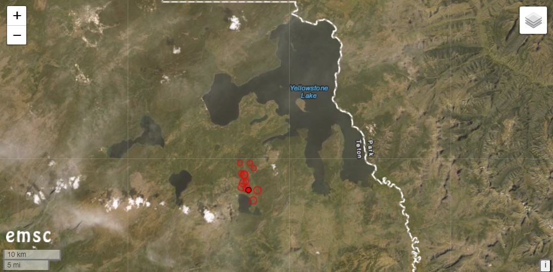
Under the US-American Yellowstone Caldera a seismic swarm is manifesting itself today. The strongest quake to date was M 2.9. EMSC indicates a total of 12 quakes with magnitudes greater than 2. The hypocenters are located at shallow depths of less than 5 km. The epicenters are concentrated in a small area southwest of Yellowstone Lake. They are located in the area of Heart-Lake and Mount Sheridan. The depression of the lake was formed by folding processes at a young fault zone. Therefore the swarm quake could be of tectonic origin. However, there is also a thermal field at the lake, so hydrothermal influences could come into play. The Heart Lake Geyser Basin is also known for its thermophilic archaebacteria, which occur here in a basic environment.
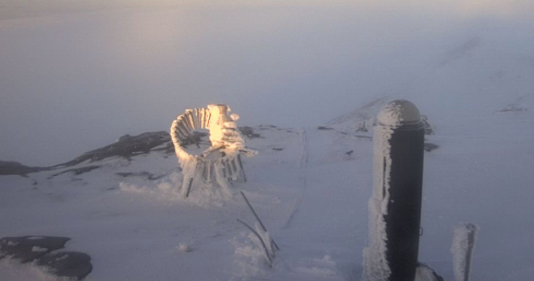
Irazu: Antennas collapsed
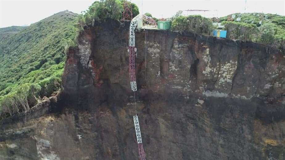
Yesterday at the Costa Rican volcano Irazu, 2 telecommunication antennas and a building collapsed and fell into the abyss near the crater. The abyss had been created by a colossal landslide in the summit area of the volcano in late August. Before that, crevasses had formed and there were hundreds of ground tremors.
The Volcanological and Seismological Observatory of Costa Rica (Ovsicori) reported that during an overflight it was discovered that the building and two antennas had collapsed towards the cliff. Whether there was another landslide is not clear from the report. But what you can see very nicely on the photos is the sheer size of the landslide in the volcano flank.