Strong earthquake shakes Iceland

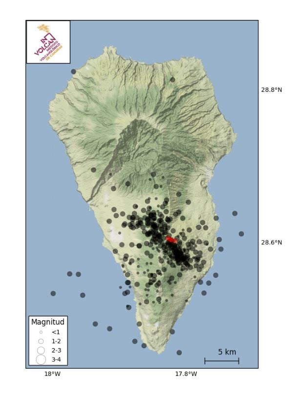
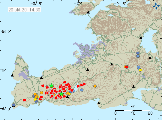
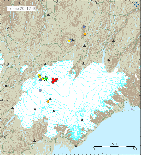
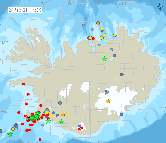
This morning Iceland was shaken by a strong earthquake of magnitude 5.7. The hypocenter was located at a depth of only 1.1 km, according to IMO. The epicenter was located on the Reykjanes Peninsula, more precisely, 3.3 km south-south-west of Keilir. This is a mountain of volcanic hyaloclasti. These are fragments of volcanic glass. Keilir is located about 10 km northeast of Grindavik and thus in the area that has been hit by inflation-related earthquakes since the beginning of last year. However, the magnitude of the current main earthquake suggests that the origin was tectonic in nature. However, it could be that the ground deformation triggered by inflation caused stresses and thus a fault zone was activated. But this is so far only speculation on my part. Therefore, I am eagerly awaiting a report from IMO to assess the situation.

There were numerous pre- and aftershocks. Among the aftershocks, there were 34 tremors with magnitudes greater than 3. IMO has so far registered a total of 378 tremors in the affected region within 48 hours.

The earthquake occurred at 10:05 UCT. It was felt in a wide radius. There are no reports of damage yet.

Strong earthquake Mw 7.6 shakes Loyalty Islands

The Loyalty Islands region has just been shaken (13:19:57 UTC) by a strong earthquake of magnitude 7.6. The epicenter was located 401 km east of Tadine on New Caledonia. The earthquake focus was located at a depth of only 2 km. Should the information be confirmed, then in my opinion a tsunami is imminent. The strong earthquake was preceded by several quakes with magnitudes between 6.2 and 5.7.

Hawaii: Earthquake Mb 4.7

Big Island Hawaii was shaken by a moderate earthquake of magnitude 4.7 (EMSC). The USGS gives a magnitude of 4.0. The depth of the earthquake focus was located at 35 km. The epicenter was located 10 km southeast of Pahala, in the area of the lower west rift. The quake occurred at 4:15 am UCT. During the morning, there were 5 more tremors in the 2 range.

A look at the map also reveals that there was a small earthquake swarm at Mauna Loa. The quakes manifested northeast of the caldera and also had magnitudes around 2. The hypocenters were at shallow depths.

Sulawesi: Earthquake Mw 6,4

Last night there was a strong earthquake on Sulawesi. According to EMSC, it had magnitude 6.4. USGS determined a magnitude of 6.2. The hypocenter was located at a depth of 10 km. The epicenter manifested itself again 34 km south of Mamuju. According to media reports, this time there was damage and at least 34 fatalities. This quake must not have been the last one, because especially on Sulawesi the stronger earthquakes like to come in series.

Mauna Loa: New earthquake M 4.1

The Mauna Loa in Hawaii was shaken by an earthquake of magnitude 4.1 last night. The epicenter was on the northwest flank, 29 km east of Captain Cook. The depth of the hypocenter was estimated to be 4.7 km. It was the strongest earthquake that had manifested itself for several months under the largest volcano in the world.

Kilauea: Swarm quake with inflation

But seismic activity is not only high under Mauna Loa, but also under the neighboring volcano Kilauea. There was an earthquake swarm there in the last few days which was accompanied by a short but strong phase of inflation. The HVO wrote that on December 2 more than 220 earthquakes occurred within 24 hours. These earthquakes occurred in clusters under the caldera and the Upper East Rift Zone, at depths of 1-4 km. The inflation was 12-14 µrad. Since then the seismic activity has calmed down again. However, earthquakes are still recorded.
On the live diagrams it can be seen that a total of more than 250 earthquakes had occurred in the Kilauea area. The inflation is also very visible.

Cumbre Vieja: Swarm quake on La Palma

Already on Saturday, the Volcanological Institute of the Canary Islands (INVOLCAN) has detected more than 50 earthquakes of low magnitude under the volcano Cumbre Vieja. The epicenters of the swarm were mainly located in the north of the volcano. They gathered in an elongated cluster that extends in a northwest-southeast direction. The hypocenters of the quakes were located at depths of around 30 km and thus in the area of the asthenosphere from which magma likes to rise into the earth’s crust. The strongest quake had the magnitude 1.2.

The scientists of INVOLCAN, however, reassure the population and say that the earthquake swarm is not a threat and that it does not indicate disturbing changes in the volcano. However, it should also be noted that increased carbon dioxide emissions were already registered in August. The quakes could well be related to magma intrusion.

Not only under La Palma it has been quaking more and more frequently for several months. Other regions of the Canary Islands are also affected. For example, there has been an accumulation of earthquakes in the area of El Hierro, on Tenerife (where there was a quake M 1.7 today) and under the sea floor between Tenerife and Gran Canaria. The quakes remind us that the volcanism of the region is only dormant and far from extinct.

Iceland: Earthquake M 5.6

On the Icelandic Reykjanes Peninsula, the earthquake struck this afternoon at 13.43 UCT with a magnitude of 5.6, with the epicenter located 3.9 km west of Krýsuvík and only a few kilometers from Grindavik. The hypocenter was located at a depth of 3.3 km. The quake could be felt in large parts of southwest Iceland and shook the capital. For Iceland it was a strong quake. There were numerous aftershocks, although I would honestly say that the main quake triggered a seismic swarm. So far 219 quakes have been registered, 12 with magnitudes greater than 3.

Alaska: Earthquake Mw 7,5

Off the coast of the US state of Alaska, the earth shook last night with a magnitude of 7.5, the epicenter being located 84 km southeast of Sand Point. This is a place on the Aleutian island of Unalaska. The hypocenter was at a depth of 40 km. Despite the relatively large depth of the earthquake epicenter there was a tsunami alarm. The same applies to larger damages. The region is only sparsely populated. In relative proximity to the location of the earthquake are some volcanoes that are classified as potentially active: Mount Makushin, Mount Okmok and the volcanic island of Bogoslof, to name only 3. The volcanism of the region is directly related to the Aleutian subduction zone where the earthquake occurred.

As is typical for earthquakes of this magnitude, there were numerous aftershocks. The strongest one had the magnitude 5.9 and further aftershocks must be expected.

La Palma: Seismic swarm

The Canary Island La Palma was again hit by a swarm quake yesterday morning. The seismographs recorded 25 tremors with magnitudes between 1.6 and 2.0. The hypocenters were at depths between 20 and 45 km. In this area of the asthenosphere, it is usually ascending magma that triggers light tremors. The epicenters were located in the south of the island, which was formed by eruptions.

In addition, seismicity is also increased in other regions of the Canary Islands. For example, it shook unusually often in the area of Tenerife and El Hierro is also still affected by sporadic quakes. Although there are no indications of an imminent volcanic eruption, in the longer term an eruption could occur again. In my opinion the most promising candidate is La Palma.

Bardarbunga: Earthquake M 4.8

Under the Icelandic glacier volcano Bardarbunga one of the strongest earthquakes of the last months occurred. It had a magnitude of 4.9 and its epicenter was 8.3 km east of the caldera. The epicenter of the earthquake was located at a depth of 4.8 km. A total of 12 earthquakes were recorded in the area of Vatanjökull within 48 hours.