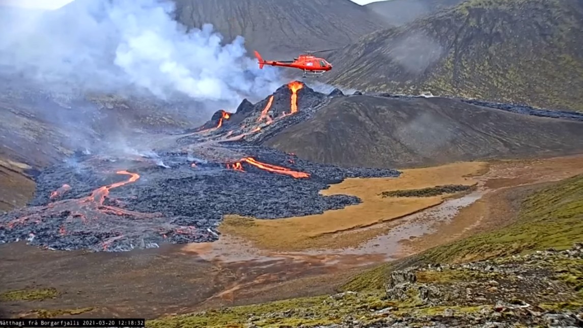
 Last night, the expected volcanic eruption began in Iceland. Although it was known that magma was accumulating underground, the start last night, at 20.45 local time, nevertheless came as a surprise, as all parameters actually pointed to relaxation of the situation. In the Geldingadali valley, on the southeastern edge of Fagradalsfjall, a 500-700 m eruption fissure opened. A series of smaller lava fountains emerged, feeding 2 lava flows. Yesterday evening the eruption was still relatively small, just as volcanologists had expected. There have been no major explosions so far, it is a purely effusive eruption. Ash clouds and an accompanying impairment of air traffic are not expected. However, Keflavik Airport could be affected, as it is located only a few kilometers from the eruption site. The greatest impairment is likely to come from gas emissions, which are often associated with fissure eruptions. Especially in the valley where the eruption is taking place, life-threatening gas concentrations could result if there is no wind. However, it is almost never windless on Iceland.
 Marc Szeglat
Etna: Paroxysm No 15 has started
 Original news 9:15 a.m.: Even as I typed the report below, Etna started through and began Paroxysm No 15. The tremor shoots up and an ash cloud is ejected, rapidly increasing in size. In addition, a lava flow begins to flow. Visibility conditions are poor, but the localteam is attempting a livestream. They are located to the east of the volcano, in a parking lot below Valle del Bove.
Update 10:25 a.m.: The paroxysm is in full swing and may have reached its peak. Gaps in the clouds give a view now and then, but most of the livecams are below the cloud line. Only the webcams above 1900 m have consistently clear views. These include a thermalcam of the INGV and the SkylineCam near the upper cable car station. So far, the paroxysm is running without any big surprises.
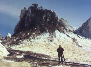
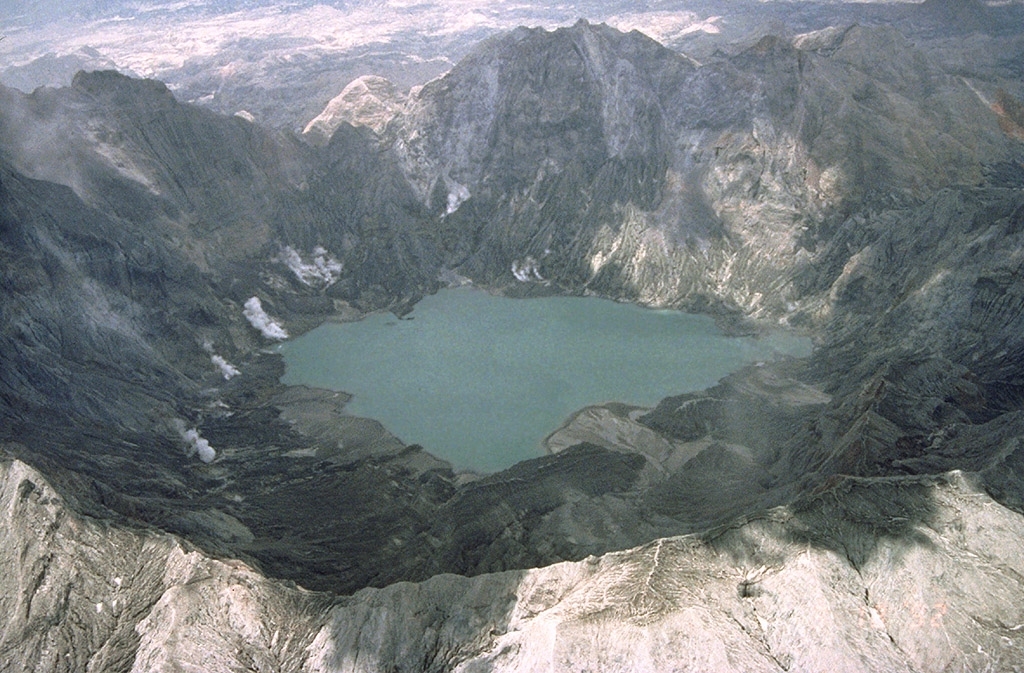
Oldoinyo Lengai: The holy mountain of the Masai (1996 until 2004)
Author Chris Weber
The 2nd part of Chris Weber’s Ol Doinyo Lengai report describes what happened at the volcano in Tanzania, between the years 1996-2004.
Report on Lengai 17 August 1996
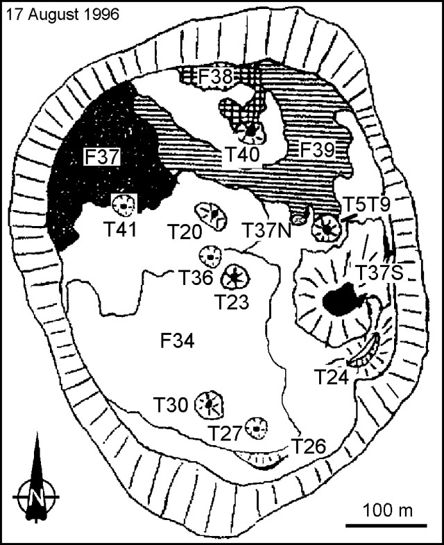 Christoph Weber climbed Lengai on 17 August and he observed a lava fountain up to 3-m-high on T37. During his entire time of visit lava still poured out. Beside activity at T37, Weber saw some quite fresh black Aa and Pahoehoe lava flows on the crater floor. He estimated the thickness of the fresh flows as typically 20-30 cm. Fresh flows were easy to distinguish because they may change from black to grayish white as they cool within days. They were often stacked, particularly on flow field F37, the one most active at that time, forming a composite of new flow material about a meter thick overall. Because of the rough irregular surfaces on some flows, their contacts with successive flows often contained considerable void space. Many of the flows were tube-fed, the tubes typically being 10- to 150-m long.
Report on Lengai 6 August 1998
Observation of the crater from 6 August 1998, 0800 until 7 August 0800 by Chris Weber. On 6 August at 0800 an eruption started at hornito T37N1. This hornito has a platform about 5 m above the surrounding area while it is highest peak at the northern flank is about 8 m high. A little splatter cone had build up on this platform where foaming white to pale grey carbonatite lava splashed out and fed short lava flows with a few meters length down the west-slope of T37N1. Most of the lava went into older lava tubes west of this hornito. The vasiculation of the gas rich lava was high. The activity stopped around 1100 with a 4 m drop of the lava level in T37N1.
On the same day at 1400 lava splashed out of two openings close to it is peak of hornito T48. The black degassed very liquid lava fed little lava flows reaching 8 m of length down the east-slope. The activity stopped shortly after 1600.
On 7 August at 0408 a loud explosion blew of the top and northside of hornito T49 after several earthquakes during the night. The earthquakes seamed to have shallow and deeper hypocenter in the volcano. Rocks of this hornito up to 1 m3 were thrown or rolled a few meters to the north by this explosion. Right after the explosion a lava fountain (fire curtain) approximately 15 m high continued until 0413 with a loud turbojet-noise. Pahoehoe lava with little viscosity (1-5 Pa s) which splashed down north of the hornito traveled fast to the north and west.. The 10-20 cm thin flow stopped moving shortly after the end of the eruption. The amount of erupted lava was about 70-100 m3. Lava pearls up to 4 mm diameter and fine ash were transported at least over 200 m by the wind in northwest direction. The fountain had a dark red glow. The hornito lost less than one meter of the 6 m elevation., whish it had before the explosion.
At 0615 on 7 August hornito T44 started activity for an unknown time. Black liquid lava splashed out of it is 6 m high peak and splattered on the flanks of the cone. No lava flow was observed until 0815.
T40 degassed with mild turbojet-noise. The lowest point [ X ] of the crater-rim over the crater-floor in northwest was 20 cm.
Report on Lengai 3 until 11 Oktober 2000
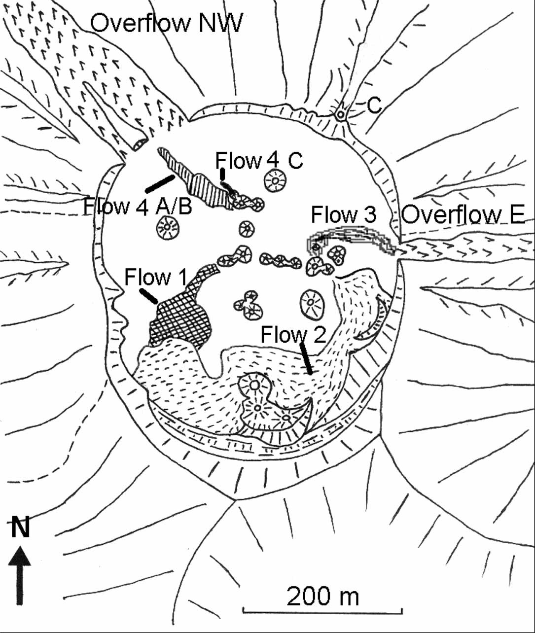 Eruptive activity: On 3rd Oct. from 1200 until 1350 hours spattering occurred in the saddle between T49 and T49B out of a small vent. Two little lava flows were observed at the northern and southern flank of T49 during that time. At 1350 the west side of T49B collapsed and released out of an approximately 6 m wide and 5 m high gap a sudden flash flood of lava. Parts of the collapsed wall of T49B were washed towards the west as big blocks. Within a few seconds the flow had reached halfway between the cone and the NW Overflow. After 5 minutes the flow had reached its final extent about 40 m short of the NW Overflow (See map of flows: Flow 4A). The lava flow was up to 5 centimeter thick and later Aa flows were several decimeters thick.
Until 8th Oct. lava spattering and many small lava flows (formed from overflowing the vent, as spatter fed flows or emitted from small new vents and fissures) had nearly closed the gap in the west wall of cone T49B. Only close to the top of T49B spattering occurred on the evening of 8th Oct. On the morning of 9th Oct. at 1035 hours nearly the same west flank of new lava collapsed in the same manner as on 3rd Oct., leaving a 7 m wide and 7 m high gap. Lava went in a flash flood within seconds towards the NW and stopped just 10 m before the NW Overflow. The flow covered the Flow 4A and is shown in the flow map as Flow 4B.
During the afternoon of 9th Oct. T48 had strong degassing and for only 10 minutes ejection of tear-drop lapilli occured. After this event T48 went quiet for the rest of our visit. Right after sunset of 9th Oct. at 1810 hours a crack opened at the SSW base of T49C with a sudden noisy gas jet followed by a 10 minutes spraying of lava droplets and sperical lapilli up to approximately 10 m high. A small lava flows (Flow 4C) were emitted too and moved NW. From there on until our descent on 11th October no flows were observed, meanwhile the lava lake inside T49B was still in motion and heavily splashing and degassing.
Accident: Jürgis steped into a little lava flow in October 2000.
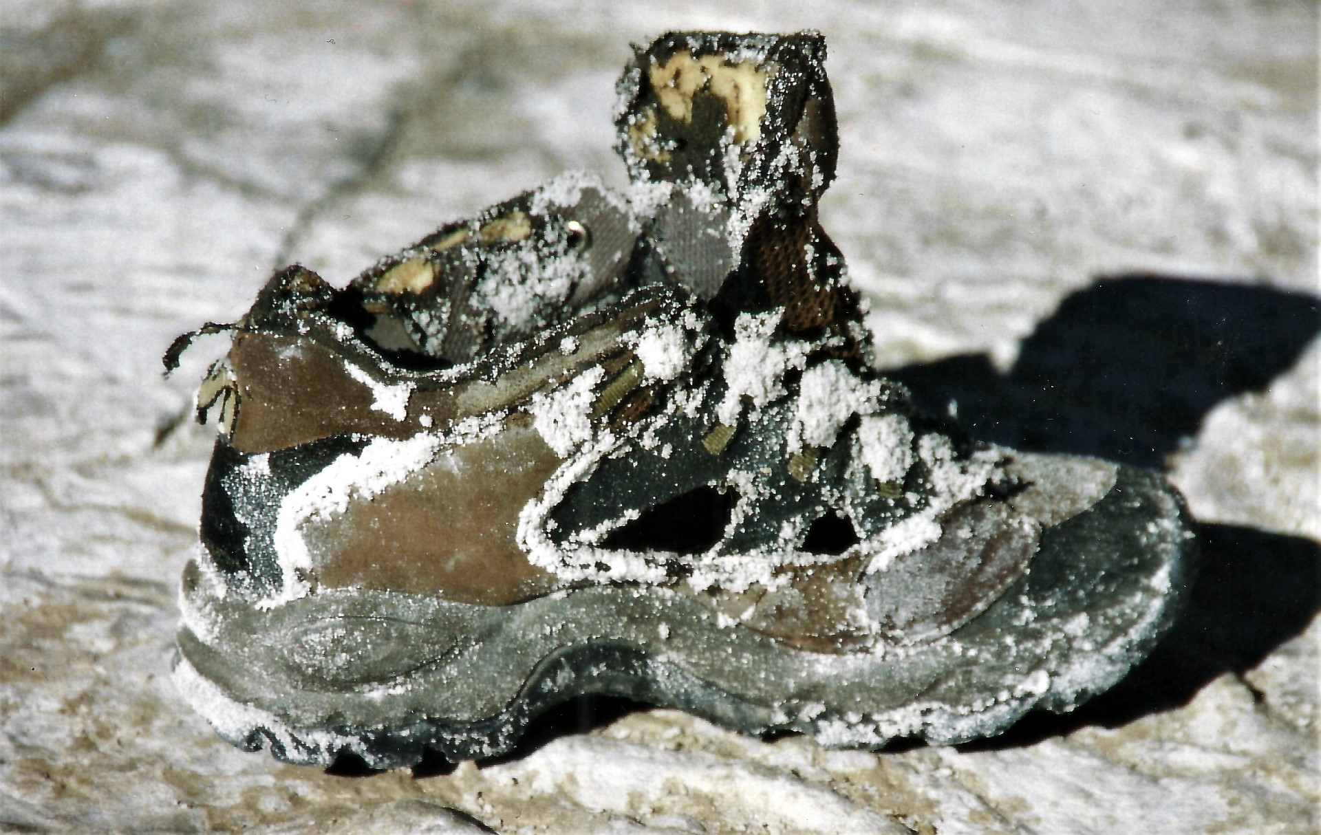 In the evening Oct. 3rd, 2000 small lava flows were to be seen again at Hornito T49, so that I called the geologist of the IMPG team, Jürgis Klaudius, who was already resting in his tent, to have a look. He was curious and to hurry up, he put on his sneakers instead of his mountain boots, and jumped out of the tent. We went to the lava flow in the dark and then a scream from Jürgis followed. He briefly had stepped into a 20 cm high lava flow at a temperature of about 500 degrees, which was flowing across a flat terrain and just looking black in the dusk. All light plastic and gorotex parts of his sport shoe were burned, the leather parts and the sole were left as a framework.
The consequences were quite fatal. Despite my good first aid and quick treatment of the burned injuries, Jürgis had to be evacuated from the mountain after two more days with his infected foot on 6th August. Since an attempted air rescue by heli failed because of non capacity, only the rescue down the steep mountain slope remained. In the steep upper part, over 45 degree, Jürgis had to slide down on his butt with his injured foot forward wrapped into bandage. This was painful and distroyed his trousers. In the middle of the way down, two of us gave him a support and when it got flatter, the four of us rescuers shouldered the tired man piggyback changing every 10 minutes one after another. For this descent we needed about 8 hours instead 4 hours or so.
Following, Jürgis, me and driver Mike had an 8 hour drive through the night into hospital in Arusha. Next morning I had already rebooked the flight from Jürgis towards Germany and then Mike and I started our journey back to the Lengai, where I made the ascent with a load of 30 kg luggage early in the following morning. Later on when Jürgis had returned to Germany a succesfull skin transplantation took place. Luckily everything went fine again without immobility consequences.
Report on Lengai 18 until 22 Oktober 2002
By the arrival 18th June the fresh looking and still black lava flows were visible from T49B on a length of 120 meters towards western directions. From T46 black lava flows streched towards NW, W, SW, and South on a length of 20 to 80 meters. The hornito T37B was covered with still black lava and propably had erupted recently. The flanks of T48 as far as to T44 were covered with black lava lapilli also propably from recent activity. The diameter of the T49 base (eruption center) increased strongly compared to august 2001.
A new eruptioncenter was clearly visible half way between T46 and the West overflow an could be numbered as T54. The eruption site of T54 was an open lava pond with an overflow of about 40 meters towards the west. Black lava had covered older lava flows who had left the crater on his west side in Febuary 2002. A lava lake bubeling deep inside T48 was clearly heard during the days of our observation. The fumarolic activity and its temperature (> 125°C) increased also from summer 2001 until summer 2002. Three recognizable relativly deep released single vibrations occured during our visit
 Activity and small lava flows were observed from T49B. On 18th June lava spattering from the top of T49B went on in intervals of intensitiy from 14:00 until 19:00 hours. The maximum height of the lava fountains of was arround 3 meters. A litle lava flow went from the top towards the norh east for about 50 meters. During the day of 19th June spattering occurred with a duration everedge of 30 minutes followed by one and a half our breaks of now activity until 04:15 hours in the afternoon. No more activity outside hornito T49B and other hornitos was observed until 22nd June. On 22nd June arround 10 m3 collapsed from the wall below the summit of T49B into the crater.
Report on Lengai 10 until 14 February 2004
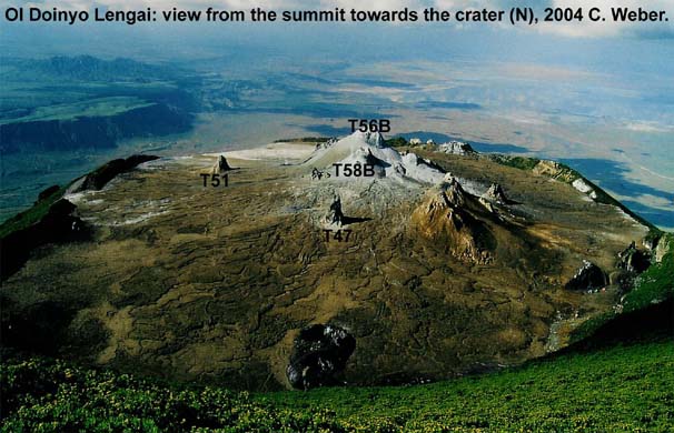 On 10 February 2004, Chris Weber and others visited Lengai for 5 days. The summit of the tallest hornito in the center area of the active crater at Oldoinyo Lengai was at approximately 2886 m altitude (GPS), standing about 33 m above the surrounding crater floor to the north. This tallest hornito at the T49 location (T56B) was not active anymore, while T48B (T58B) had a lava lake deep inside it’s hornito, clearly indicated by noises and tremor. The activity had changed to the common effusive and lava lake activity. This occured at the old T49 eruption center, also indicated by the activity of T49B during observation and an active new vent (numbered T49G by C. Weber) at the north flank of T49 (T56B), about half way up from its base to the north side.
This new activity propably caused two collapses (depression) in the north flank of T49 (T56B), already visible since January 2004 (first described by B. Donth). The T49G vent, hosted at the upper collaps, had a steady degassing lava lake with many overflows during the visit of C. Weber. Lava penetrated the lower collaps at T49 and lava flows reached as far as to the NW overflow. On 12 and 13 February T49B spattered lava for some hours, feeding lava flows to the west (T51), finally escaped into a lava tube system. The lava temperature very close to the lava lake was measured at 588°C. Aa lava flows not in motion anymore at flat terrain were measured between 480°C and 500°C.
References
The following references have all been used during the compilation of data for this volcano, it is not a comprehensive bibliography.
Bell K, Dawson J B, 1995. Nd and Sr isotope systematics of the active carbonatite volcano, Ol Doinyo Lengai. In: Bell K, Keller J (eds), Carbonatite Volcanism, Oldoinyo Lengai and the Petrogenesis of Natrocarbonatites, Berlin: Springer-Verlag, p. 100-112.
Dawson J B, 1962. The geology of Oldoinyo Lengai. Bull Volcanol, 24: 349-387.
Dawson J B, Keller J, Nyamweru C, 1995. Historic and recent eruptive activity of Oldoinyo Lengai. In: Bell K, Keller J (eds), Carbonatite Volcanism, Oldoinyo Lengai and the Petrogenesis of Natrocarbonatites, Berlin: Springer-Verlag, p. 4-22.
Global Volcanism Program (GVP), 1996. Bulletin of Global Volcanism Network (BGVN), Smithsonian Institution
Pacaya volcano continues to erupt volcanic ash
 Guatemala’s Pacaya is also located in close proximity to the capital: here, it is only a good 25 km as the crow flies to the center of Guatemala City. Accordingly, even moderate eruptions of the volcano often affect the capital and disrupt air traffic. Also in the last 24 hours Pacaya was active and produced volcanic ash. It rose to a height of 4000 meters. The ash drifted up to 25 km in a southwesterly direction. Ash precipitation occurred in the communities of El Rodeo and El Patrocinio. Volcanic bombs dispersed up to 500 m around McKenney crater. The lava flow on the southern flank is 1000 m long. From its front, block avalanches are coming down.
Pinatubo: Seismicity increased
 Pinatubo in the Philippines is seismically unsettled. Yesterday PHILVOLCS detected 25 volcanotectonic earthquakes at the volcano on Luzon. The previous day, there were 8 tremors. The alert status is at “1.” It is interesting that at the beginning of the phase with increased seismicity, it was stated that the tremors were tectonic in nature. Apparently, the activity has shifted. It is also interesting that the capital Manila is encircled by the two volcanoes: while the Taal caldera is located 70 km south of Manila, Pinatubo is located 100 km northwest of the capital. Large eruptions could have a correspondingly strong impact on the metropolis, depending on the wind direction.
Sangay: Ash cloud detected
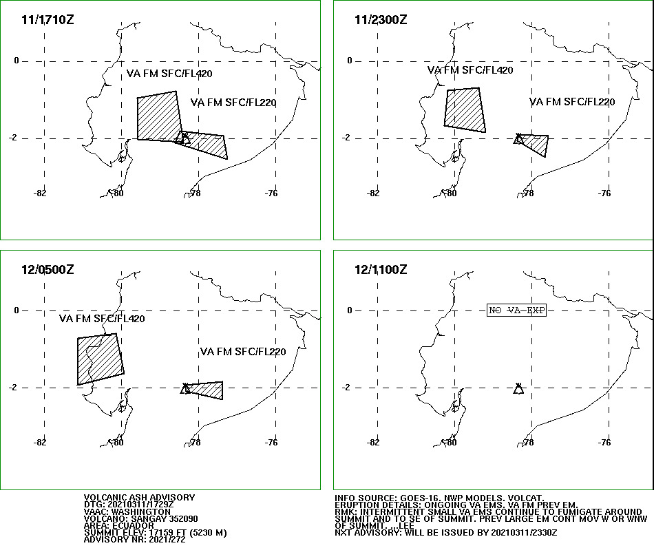 Let’s start not in alphabetical order, but with the apparently strongest eruption of the last 24 hours. This was delivered by the Ecuadorian volcano Sangay. According to VAAC, volcanic ash rose to an altitude of 12800 m and dispersed to the northwest. A smaller ash cloud rose to 6700 m and moved in the opposite direction to the southeast. Speculatively, the higher ash cloud was explosively produced and the smaller eruption cloud originated from a pyroclastic flow that descended on the southern flank of the volcano. Due to the permanent cloud cover, visual observations of the event are rare. What does exist, however, are reports that the sky darkened over the towns of Riobamba and Chambo. In addition, there were showers of ash. People showed concern. The volcanologists of IGEPN are also concerned: they fear that continued rains could trigger lahars.
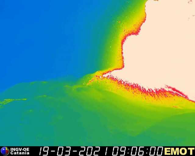
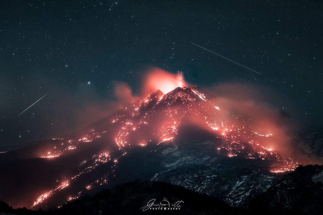
Etna Paroxysm No 12
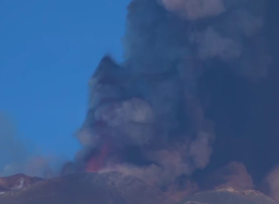 The 12th consecutive paroxysm on Etna began this morning. Activity began to increase significantly around 7:30 am. Already half an hour later, a lava flow began to emerge from the New Southeast Crater. In the meantime, the paroxysm has reached its peak.
You can see from the broad tremor base that the paroxysm was increasing comparatively slowly and has now been going on for quite a long time. It looks like it peaked at 10:30 CET (9:30 UCT). The tremor amplitude has risen even a bit higher than during the last paroxysms. Once again, the eruption takes place in unusually good weather. There is almost no wind and the eruption cloud rises vertically. VAAC Toulouse detects volcanic ash at 10,400 m altitude. On a thermalcam, one can see the lava flow that has descended far into the Valle del Bove. Obviously, however, there is only the lava flow in the eastern direction, no lava seems to be on the way in the south.
Taal: Alert level raised
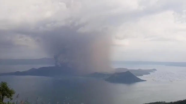 PHILVOLCS has been reporting for several weeks an increase in seismicity under the large Caldera volcano on Luzon, which caused a stir with an eruption only last January. In addition to numerous volcanotectonic earthquakes, volcanic tremors also increased significantly recently. The total number of volcanic tremor events has risen to 866 since the increased activity began on February 13. The volcanic tremors have increased seismic energy compared to previously recorded episodes and have ranged from 3 to seventeen 17 minute durations. In addition, the other parameters that indicate magma is moving at shallow depths are beginning to change: the acidity of Crater Lake increased, rising (or falling) from pH 2.79 to pH 1.59. The water is becoming more acidic because of increased volcanic gases rising. The water temperature increased to 74.6 degrees. Slight bottom deformation was detected using InSAR imagery. Concomitant changes in microgravity were recorded. New measurements have detected positive microgravity changes throughout the Taal caldera, consistent with density changes due to magma migration, magma degassing, and hydrothermal activity. All of these parameters are of concern and the alert status has been raised to “yellow.” Evacuations have not yet been initiated. Authorities remind that Volcano Island is a permanent exclusion zone. The photo shows the volcano during last year eruption.
Iceland earthquake M 5,0
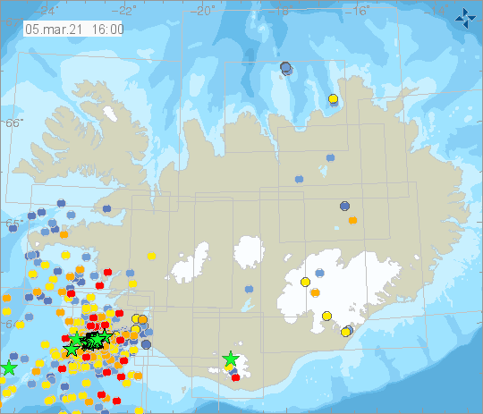 Iceland’s Reykjanes Peninsula experienced a new earthquake with a magnitude of 5. According to IMO, the earthquake was detected at 02:02. The epicenter was located about 3 km west-south-west of Fagradalsfjall. Already at 0:22 a short tremor phase was registered. It lasted 20 minutes and can be seen on the graph by the fact that also the frequency bands 0.5-1 Hz and 1-2 Hz deflected. This was followed by a general increase in seismicity, at the peak of which the M 5.0 earthquake occurred. Interestingly, the EMSC located this earthquake on the northern coast of the Reykjanes Peninsula, in the immediate vicinity of the national capital. The EMSC gives a magnitude of 5.2.
Pacaya: Eruption in Progress
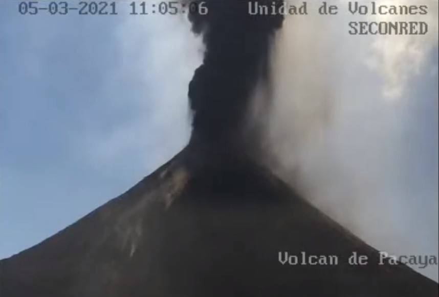 Unlike Etna, Pacaya did not take long to erupt and has been delighting with a fancy lava fountain for hours. INSIVUMEH reports glowing tephra rising up to 700 m above crater level. An ash cloud is rising up to 4500 m above sea level and drifting towards the southwest and west. In the communities downwind, ash and lapilli are raining and there is even a warning that blocks will fall. Likewise, there is a warning that lava flows may be formed, or that existing lava flows may increase. So it remains exciting at the volcano. It is noteworthy that there is a new livecam from CONRED, which is currently transmitting a livestream (see below).