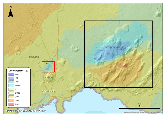
 The IMO confirmed the presumed inflation in the earthquake zone near the Fagradalsfjall volcano on the Reykjanes peninsula. The ground elevation has been 3 cm since the beginning of the swarm earthquake on 18 July. The magma inflation was detected by INSAR satellite images. The deformation took place mainly during the main phase of the quake activity between July 18th and 20th. The magma penetrated into a northeast-southwest striking fault zone, which was already discovered in 2017, when swarm quakes also occurred there. The deformation is considered part of a larger volcanic-tectonic reactivation event on the Reykjanes Peninsula. This not only results in ground uplift, but also in subsidence. Such subsidence has now been discovered in the area of the Svartsengi geothermal power plant. It started 2 days before the swarm earthquake at Fagradalsfjall and was probably caused by the underground run-off of magmatic fluids.
Month: July 2020
USA-Alaska: Earthquake Mw 7,8
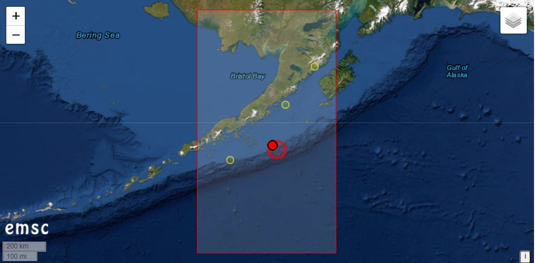 This morning a strong earthquake of magnitude 7.8 manifested itself off the coast of Alaska. The hypocenter was at a depth of 17 kilometers. The epicenter was located 84 kilometers south of Perryville. A tsunami alarm was sounded. People on the coast of Alaska and the Aleutian Islands were asked to go to higher ground. The data is from the EMSC and may still be subject to change.
Strong earthquakes could effect nearby volcanoes. A few kilometers north of Pennyville is Mount Veniaminof. The volcanoes Mount Pavlof and Mount Chiginagak are also located around the epicenter.
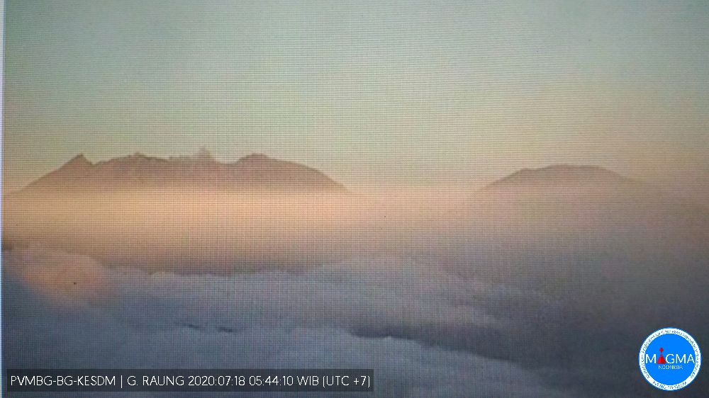
Raung with Hotspot
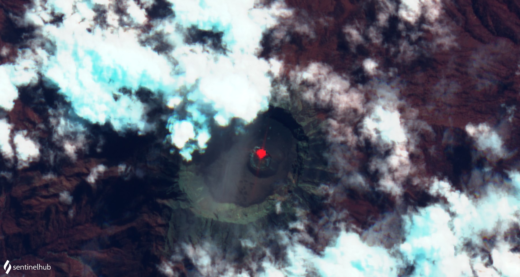 The volcano Raung is located in the east of the Indonesian island of Java and has been under special observation by local volcanologists for several days. Seismic signals signalled the awakening of the volcano. Small ash clouds were also sighted rising above the crater rim. Now there is a further indication of the increasing activity of the volcano: the sentinel satellites detected a heat source. It emits radiation with a power of 33 MW and is located at the northern rim of the small crater that had formed in the caldera in 2015. The crater is part of an intra-caldera cinder cone. The evidence suggests strombolian activity. Visual observations of the crater rim have not been reported to me. Raung is part of the Ijen volcanic massif, which also includes the better known sulfur-producing Kawah Ijen.
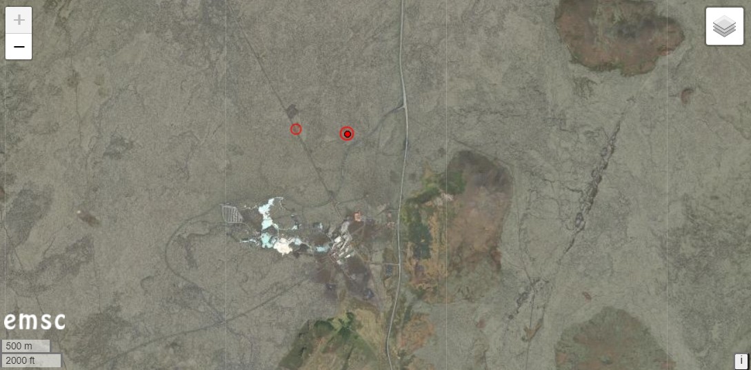
Iceland: Strong earthquake swarm on Reykjanes
 The Icelandic peninsula of Reykjanes is again hit by a strong Earthquake swarm. The strongest single quake had a magnitude of 5.0 and manifested itself 1.6 km northwest of Fagradalsfjall, with a hypocentre at 10 km depth. Fagradalsfjall is the highest elevation on Reykjanes with a height of 385 m and lies east of Grindavik. In the end, the epicentre of seismic activity shifted a little to the east, starting from the quake spot north of Grindavik where most of the previous earthquakes occurred.
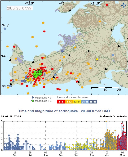
IMO recorded a total of 936 earth tremors in the Reykjanes area in the last 48 hours. 16 quakes had magnitudes greater than 3, some of them even stronger than M 4.0. I assume that the quakes are related to further magma intrusion. However, an IMO report on this is still pending. However, the Icelandic Meteorological Authority reports that the stronger earth quakes were felt in the southwest of Iceland.
Stromboli: Another strong explosion
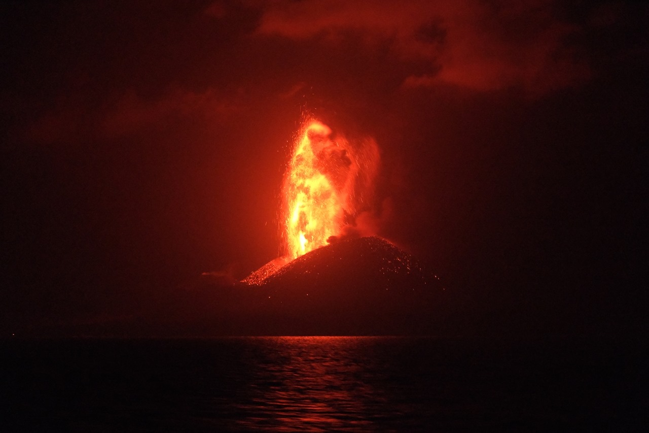
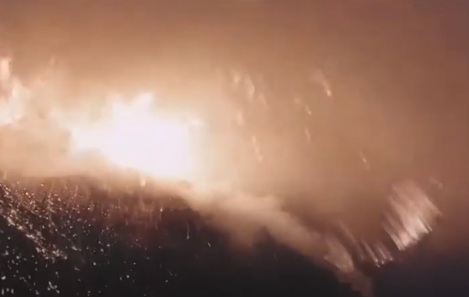 The Italian volcano Stromboli once again proved its unpredictability tonight and erupted a large amount of tephra at 3 o’clock, which covered the entire summit area with glowing bombs. On the video embedded below you can see that it was a short eruption phase with 4 explosions. At least 2 winding vents were involved in the explosions. Such unusually strong eruptions occurred in the past and cost the lives of several volcano observers. This time, however, no people should have been in the summit area, because the ascent was still blocked. Local residents report that they were woken up by a loud bang. However, no material fell in the lower part of the volcano. The eruption was weaker than on 3 July last year.
Unlike last year’s two eruptions, there was no longer period of increased activity before. On the contrary, the eruptions of the past days were comparatively weak. Only a few hours before, the strombolian eruptions increased significantly. Images of these were shared in our FB group “volcanoes and volcanism“. The only indicator for magma rise was an increased carbon dioxide emission: in the last two days the daily production increased from less than 200 tons to almost 1000 tons. Already at the end of June there were 2 measurements of more than 1000 tons per day.
Iceland: New earthquake M 4.1
 There was another strong earthquake in Iceland this morning. It had a magnitude of 4.1 and manifested itself on the Reykjanes Peninsula. The epicentre was located 4.1 km north of Grindavik and only about 1 km from the Blue Lagoon and Thorbjörn Volcano. The depth of the hypocentre is estimated to be only 2.5 km. This makes it the closest surface earthquake of this magnitude since the swarm earthquakes started on the peninsula. The local residents should have been well shaken. It remains exciting to wait and see whether reports of crevice openings will come in. Just 2 minutes earlier, there was a quake of magnitude 3.2 at a depth of 2.3 km. Further weaker earthquakes followed. In total IMO registered 40 tremors on Reykjanes in the last 48 hours.
Raung: Eruption started
 On the Indonesian island of Java, the volcano Raung has started an eruption. The eruption was preceded by a seismic crisis. It started on July 13th. The first small ash cloud was detected 2 days ago. A VONA warning was issued and air traffic on the neighbouring island of Bali was suspended. However, due to the corona lockdown, only very few flights may have been affected. In the meantime a stable eruption on a low level has occurred. During the first 6 hours of the day, volcanologists from VSI recorded 28 seismic eruption signals. They had amplitudes between 4 and 14 mm and lasted up to 150 seconds. MIROVA recorded a moderate thermal anomaly with peak values of 15 MW. One can assume strombolian activity, where glowing tephra accumulates in the crater. The alert status has been raised to “yellow.”
The last eruptions of the Raung occurred in 2015, when the eruptions started like now and increased within a few weeks to a very interesting eruption, where not only strombolian eruptions were generated, but also lava flows that filled part of the crater.
Andaman: Earthquake M 6.1
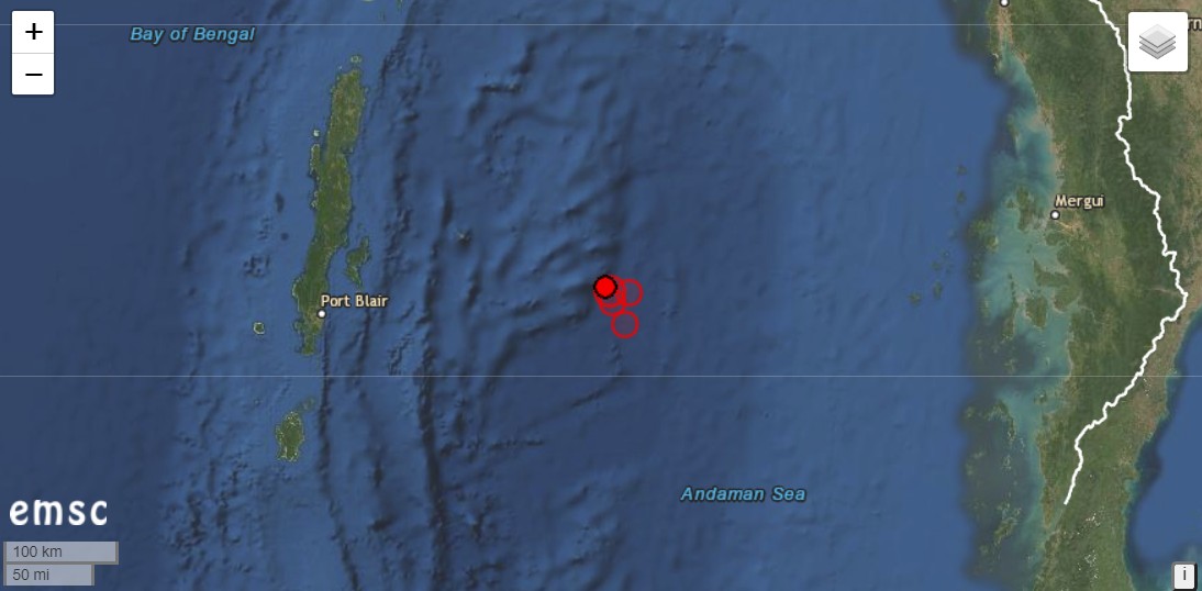 The Andaman and Nicobar Islands were shaken by an earthquake with a magnitude of 6.1. The hypocentre was 10 km deep. The epicentre manifested 236km east of Port Blair. The Indian Ocean archipelago belongs to India, but geographically it is closer to Myanmar. An aftershock of magnitude 5.6 followed at a depth of only 2 km. There had also been several aftershocks in the 4-magnitude range. Seismologists have been expecting a strong quake in the region (Andaman Sea) for some time, which could trigger a tsunami.
The quake was automatically detected.
Nishinoshima grows
 The Japanese volcanic island of Nishinoshima is growing and growing and is not only producing lava flows but also ash clouds. On 13. July these reached an altitude of 6100 m, with a cone height of 200 m.The Japanese coast guard photographed lava fountains that were as high as the cinder cone. Today the activity seems to be decreasing. The VAAC recorded volcanic ash at an altitude of 3700 m.
New observations will be made on July 20 by the meteorological observation ship “Keifu”.
Sangay: Thermal anomalies detected
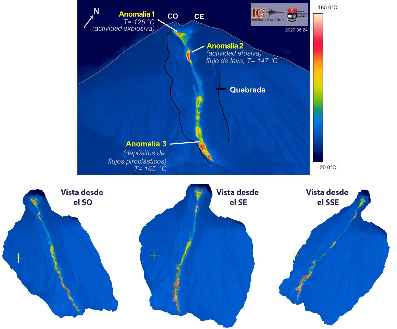 The Ecuadorian volcano Sangay is still active. Today, explosive eruptions were detected, which caused volcanic ash to rise to an altitude of 6400 m. The ash was drifted westward. In a special report of the IGEPN the morphological changes of the volcano caused by the eruptions were investigated. Most striking is a depression on the southeast flank. It was carved into the flank by lava flows, debris avalanches and pyroclastic flows. The gorge is almost 400 m wide, 4 km long and starts from the crater. Three thermal anomalies have been detected in it. 2 of the anomalies are located in the upper part of the canyon. The top anomaly is in the crater area and marks an explosive vent. The 2nd anomaly is below the base of the crater and represents the source of the lava flows. The 3rd heat source is located in the lower part of the gorge and is probably generated by an accumulation of hot deposits of pyroclastic flows.